#bannaubrycheiniog

mkwadee@diasp.eu

Having had two dry(ish) days in #BannauBrycheiniog, it is not surprising that that the third was wet and not by a little. I usually like using my paper maps and #DeadReckoning to #navigate my way around a new place but I forgot to bring my compass on this occasion and so I had to revert to #GPS (don't tell anyone else) in order to find #SugarLoaf near #Abergavenny. I couldn't see much else but at least our #hike was 12 km and so it was still worth it.

Here I am surrounded by #ferns trying to figure out where I should go in the #rain and #fog.

#MyWork #MyPhoto #CCBYSA #Android #Summer

mkwadee@diasp.eu

The second full day of our visit to #BannauBrycheiniog was devoted to visiting #PenYFan, the tallest #peak in south #Wales. This was a very nice #walk of 15 km with some steep ascents and descents but no climbing.

Starting from the car park, a path started to climb gently upwards. You can see Pen Y Fan on the horizon near the centre of the image.
Starting path to Pen Y Fan

As we approached the #mountain, we could make out a #path up towards the summit.
Path leading up Pen Y Fan

The path passes a small #reservoir and the #dam has an interesting castellated feature on it.
Dam near Pen Y Fan

Along the way there are several valleys leading to #farm #fields.
Valley and lower ground

As the path turns, you can see where you've just come from.
Path leading to Pen Y Fan

The land around the mountains are used for grazing #sheep. Here are two who have been shorn of their winter #fleeces.
Two sheep grazing

On the final steeper ascent up Pen Y Fan you can here see the craggy north side of the neighbouring mountain, #Cribyn.
The north face of Cribyn seen while ascending Pen Y Fan

Looking back south, you can make out the edge of the reservoir we passed.
South view from mountains

The path gets steadily steeper and is partially paved to provide durability and grip. The view keeps getting better.
Path leading up to Pen Y Fan

Arriving at the summit with some effort, you are rewarded with an all-round view. We were very lucky as I was told by someone that the day before, the peak had been shrouded in cloud. Dozens of other people were also enjoying the spectacle.
South view from Pen Y Fan
North east view from Pen Y Fan
West view from Pen Y Fan

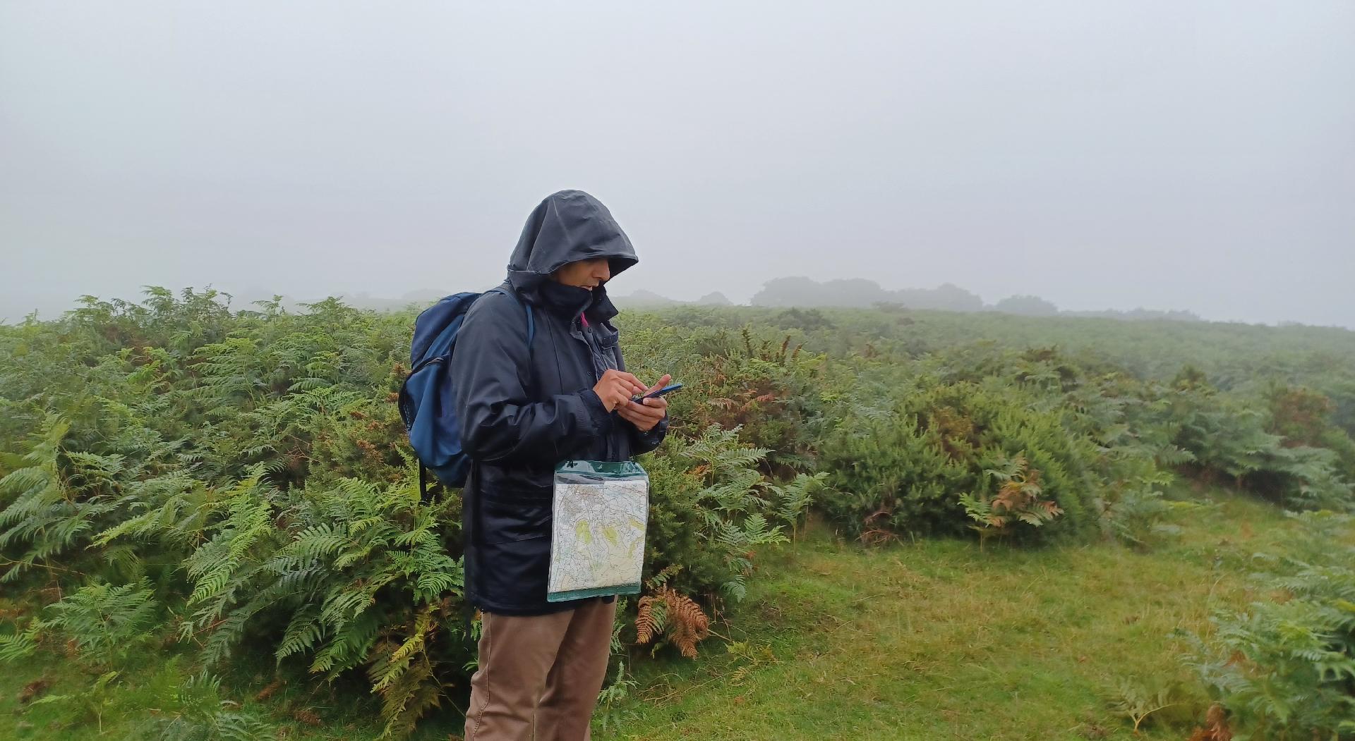
Here I am at the summit at an elevation of 886 m. From the start point, that's a climb of about 650 m.
Elsie of me at the summit of Pen Y Fan

The path back to the start is along a #ridge affording views of the valleys either side.
Return leg on ridge

The path on the ridge is not dangerous unless you get carelessly close to the edge but it is uneven and has large stones in places whereas in others, it is covered in black #peat.
Ridge path
Ridge path

Looking back towards Pen Y Fan, you can just make out the figures of people waling on the horizon.
People walking along the path to or from the summit of Pen Y Fan

The valley edge looks precarious but in summer, I don't think it is a great danger.
Edge of value up to the ridge path

In the south western horizon are a group of #WindTurbines. I am sure wind will be an important energy resource for #Wales in the coming decades.
Wind turbines on the horizon

The return to the car park as along this path down across the valley.
Path back to car park

To get to it, required us to descend some steep roughly buiilt stone stairs. For me this was the most hazardous part of the walk as I was tired by now and my knees were getting very sore. It was a relief to get back to the car.
Stairs down the valley side

#MyWork #MyPhoto #CCBYSA #DSLR #Nikon #D7000 #Summer

mkwadee@diasp.eu

In the afternoon of the first full day in #BannauBrycheiniog, we travelled to #Crickhowell or #Crughywel to climb #TableMountain, which is also the location of an #IronAge #fort. So, equipped with my #OrdnanceSurveyMap we made steady progress up the slopes, on #roads and then #footpaths, often across #farmland. The total walk was 12.5 km.

Approaching the summit, you can see that the area is covered with #ferns.
Summit of Table Mountain

Looking south from the summit, Crickhowell can be seen in the valley below.
Crickhowell from Table Mountain

On the descent, this is the profile of the western side of the mountain.
Western face of Table Mountain

Also on the way down, here is a view looking west once more with the valley in the mid ground and hills in the background. Natural haze makes the distant mountains seem to fade away.
Rolling hills and countryside

Here's a moment where the #Sun is shining through clouds giving an eerie effect in the fading light on a hill, while the foreground is silhouetted.
Rays shining through clouds onto a hilly landscape

#MyWork #MyPhoto #CCBYSA #DSLR #Nikon #D7000 #Summer #Wales

mkwadee@diasp.eu

Finally on the theme of #flow, I photographed the #waterfall #SgwdGwladus from the other bank and was able to get much closer to it and so I used the same method to give different impressions of gushing or a freeze frame.

Shutter speed: 1/80 s
Waterfall, fast shutter speed

Shutter speed 1/15 s
Waterfall, slow shutter speed

Incidentally, if you're wondering if there's anything special about 1/15 s, well it's the longest exposure I could get with the juddering of my hand held camera became too noticeable..

#MyWork #MyPhoto #CCBYSA #DSLR #Nikon #D7000 #Summer #Wales #BannauBrycheiniog

mkwadee@diasp.eu

Looking at the way photographers photograph moving water is quite interesting. In order to give the impression of rapid, gushing motion, the exposure should be longer and so, rather than photographing in #AutomaticMode, it is better to use #ShutterPriority and adjust #ShutterSpeed to achieve the desired effect.

Here the shutter speed in automatic mode is 1/100 s.
Fast shutter speed waterfall

And here is the same in shutter priority mode with a speed of 1/15 s, which makes the water look that much more dynamic.
Slow shutter speed waterfall

#MyWork #MyPhoto #CCBYSA #DSLR #Nikon #D7000 #Summer #Wales #BannauBrycheiniog

mkwadee@diasp.eu

We recently visited the #NationalPark in #Wales which used to be called the #BreconBeacons but is now known as #BannauBrycheiniog. I practised pronouncing it a few times and it's actually quite easy and roles off the back of the throat without a problem for someone who speaks Urdu. There was lots of walking to be done and on the morning of the first day, we went to the #waterfalls at #Pontneddfechan. The return trip was about 10.5 km long. It was a nice way to whet the appetite for hiking in this picturesque part of the country.

The river is called #NeddFechan and over that stretch falls about 200 m in total. This #photograph gives you a good flavour of the scenery.
Rapids on Nedd Fechan

#MyWork #MyPhoto #CCBYSA #DSLR #Nikon #D7000 #Summer