#hurricaneida

christophs@diaspora.glasswings.com

American Red Cross #HurricaneIda auf Twitter:

"Meet Cody! He's a Golden Retriever who loves kids.
🐕 💛 Has three AKC Canine Good Citizen titles
✨ Novice Trick Dog title
🥰 Belly rubs are his favorite
🏥 Loves visiting Evans Army Community Hospital
Thank you Cody for all you do for others! https://t.co/viHStH6zyl" / Twitter

@Dogs of the Federation #dogs #dog

https://twitter.com/RedCross/status/1436366245234888710

psych@diasp.org

Bow Bridge (Central Park)

Last for now....It was not easy getting to Bow Bridge from several directions.
On the bridge, the plants seem very well watered. As do the trails to and from the bridge.
In the background is The Dakota and San Remo (Central Park West)

More vintage Central Park photos (and NYC) @ http://www.fenichel.com/NYNY.shtml
Recent - pandemic-era - 2020-2021 images: http://www.fenichel.com/NYNY.shtml

#NYC #myphotos #fenfotos #CentralPark #HurricaneIda #flood #BowBridge #photography #NewYork

dredmorbius@joindiaspora.com

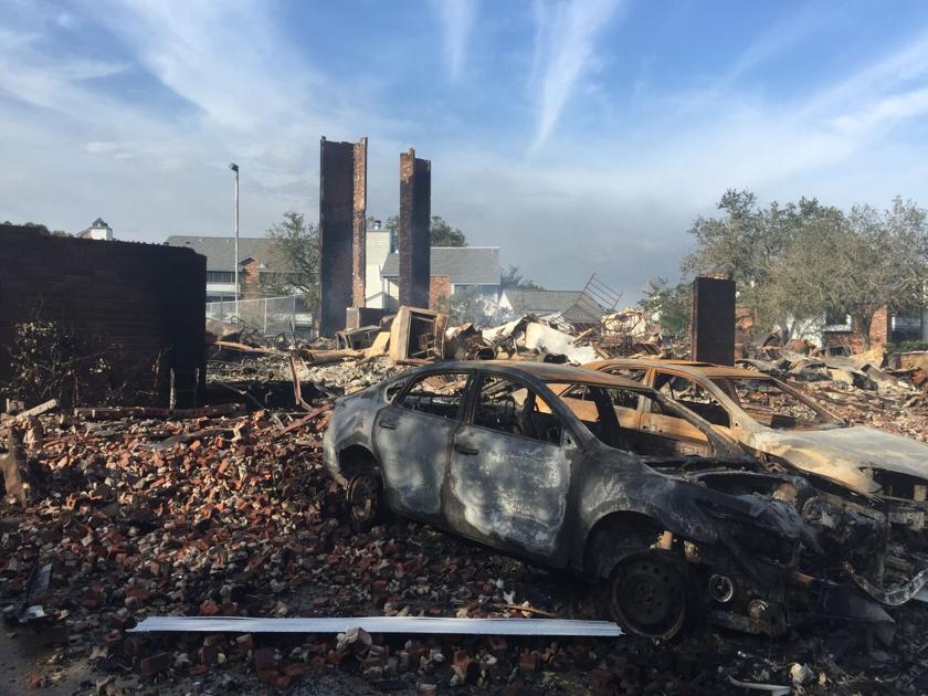
Hurricane Ida Aftermath: 'Leave, absolutely, if you can': Jefferson officials warn of grueling weeks ahead after Ida

... Jefferson President Cynthia Lee Sheng put the entire parish under a boil-water advisory after uprooted trees caused hundreds of water main breaks. And about 80 people had gone to PARD Playground in Harvey by Tuesday in search of bus rides to state shelters out of the Ida disaster zone, said Jefferson Parish Council member Byron Lee.

In New Orleans, Mayor LaToya Cantrell had staged buses for such a post-storm evacuation if necessary. But there the water was flowing, and food and water distribution sites had been set up on Tuesday. The mayor said the buses were not yet necessary. ...

Water and power are out throughout much of southeaster Louisiana. The city of New Orleans has some basic services, but even there power outages and boil-orders for water have been issued. Elsewhere, water may be out for days, power for weeks. Roads are impassible, and many residential, commercial, government, and industrial structures are severely damaged.

Recovery will, once again, be a long haul.

The good news:

  • The levees held.
  • There are only two reported deaths.
  • There's been no disorder.
  • Search, rescue, and recovery resources were positioned in advance and have entered into the area.

https://www.nola.com/news/hurricane/article_83e0aae4-0a96-11ec-a422-570388492f2c.html

#HurricaneIda #NewOrleans #Louisiana #Recovery #JeffersonParrish

dredmorbius@joindiaspora.com

Hurricane Ida Rapidly Intensifies Into Dangerous Category 4

Hurricane Ida was rapidly intensifying early Sunday, becoming a dangerous Category 4 hurricane on track for a potentially devastating landfall on the Louisiana coast while emergency officials in the region grappled with opening shelters for displaced evacuees despite the risks of spreading the coronavirus.

The National Hurricane Center predicted Ida would become an extremely dangerous Category 4 hurricane with 130 mph (209 kph) winds — that happened early Sunday ahead of an expected afternoon landfall. The storm arrived on the exact date Hurricane Katrina ravaged Louisiana and Mississippi 16 years earlier.

Given very high Gulf sea surface temperatures and a slow-moving storm, it's possible Ida might even reach Category 5 wind speeds (greater than 157 mph, 252 kph, 137 kt) before landfall.

Storm damage is a function of wind, rain, and storm surge, a rise in the overall level of water similar to a tsunami (though lasting much longer), itself interacting with tides, as well as the size of the storm ("wind field"), and the terrain and preparedness of the regions it strikes. The most dangerous side of Northern-hemisphere storms tends to the the north-east quadrant, so that storms passing to the west of a location tend to do the most damage. Ida is tracking about 10--20km (6-12 mi) west of downtown New Orleans. The final factor is response: rescue, recovery, and emergency shelter and services.

Another factor for Gulf hirricanes is the oil industry. This is a mainstay of the region, and there are numeous offshore platforms, onshore refineries and processing plants, storage facilities, pipelines, and support services including ports and harbours. All of these are affected by the storm. Reports are that 91% of Gulf oil production has been shut down.

Ida is a smaller but more intese storm than Katrina, 16 years ago. Rainfall levels are higher, storm surge is lower, and wind speeds look to be higher. The major damage mechanism of Katrina was the overwhelming of New Orleans's levee system. There's been substantial improvement of that in the decade-and-a-half since. Peak storm surge looks to be 12--15', as compared with an estimated 20' for Katrina, though the peak measured surge from Katrina was 12'. Ida is slow-moving, meaning that rainfall totals will be greater than Katrina (20"+ vs. 15"), over the duration of the storm. Ida's track will take it up the Mississippi-Ohio river system over the next five days, ending as a long band of intense rainfall over the Appalachians, with the cone of probability extending from a bare-skimming of northern Georgia to Pennsylvania and New York. That's where the system center might fall. The projected track crosses Louisiana, Mississippi, Tennessee, West Virginiana, Maryland, Pennsylvania, New Jersey, New York, and southern New England before heading into the Northern Atlantic. That track is similar to the one followed by Katrina.

The storm errupted and intensified quickly enough that there was no time to organise an evacuation of New Orleans itself. I'm bothered by this fact, and suspect this aspect will be revisited in the future. At-risk coastal Gulf communities may need to recognise and plan for having to undertake major evacuations on 48 hours' notice. That's probably going to involve bus or rail rather than private automobile transport. From what I've seen of highway traffic, it's been light. Google Maps shows no congestion out of the area, though road closures are in effect in and around New Orleans. News and governent sources have been warning since last night that it's too late to begin an evacuation --- being caught out by the storm on the highway is far riskier than sheltering in place.

Low-lying regions around New Orleans outside the levee system have been evacuated.

I've been discussing the storm for the past three days here.

Since first sighting, Ida has become stronger than initially projected. The track has varied, though it's remained just west of New Orleans for the past two days.

https://www.npr.org/2021/08/29/1032157721/hurricane-ida-rapidly-intensifies-into-dangerous-category-4

#HurricaneIda #NewOrleans #Louisiana #TropicalStorms #hurricanes

dredmorbius@joindiaspora.com

Tropical Storm Ida forms, could strike Louisiana as Category 2 hurricane

Tropical Storm Ida is expected to make landfall on the Louisiana coast at Grand Isle as a strong Category 2 hurricane Sunday afternoon, pushing the Gulf of Mexico into coastal areas and dropping extremely heavy rain far inland. The storm will then head north and northeast towards Baton Rouge and Monroe.

It's the most serious weather threat to Louisiana of the 2021 Atlantic Basin hurricane season, after a record-breaking 2020 that saw four named storms - including Category 4 Hurricane Laura - strike the state. It's predicted landfall would bring it ashore on the 16th anniversary of Hurricane Katrina, the costliest storm in U.S. history.

https://www.nola.com/news/hurricane/article_0dd9a3d8-06a3-11ec-8b3e-ef7a2e559634.html

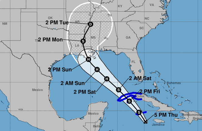
Tropical Storm Ida is forecast to arrive at New Orleans, LA about noon--2pm Sunday (local time), at hurricane strength.

The cone of probability is relatively narrow, though landfall locations could still vary considerably. Intensity is likely to be high given high Gulf sea temps.

Louisiana is also seaing an all-time peak Covid infection rate.

US National Hurricane Center:
https://www.nhc.noaa.gov/refresh/graphics_at4+shtml/234304.shtml?cone#contents

Ida looks to be slow-moving and will remain over or upstream of New Orleans for 18--48 hours, with rain intensities of an inch an hour (25.4 mm/hr), which could be over 18--36 in (500 -- 1000mm) of rain.

Nullschool Arrival Forecast at noon CST, with 968 hPa, winds are hard to say (Nullschool's forecasts run low, stated is 70 mph, could exceed 110 mph), and 97mm/3hr rain (3.83 in/3hr). I also don't get storn surge, though the eye looks as if it may pass very slightly west of NoLa, which means that the storm surge on the east of the city will be amplified.

This could be a major storm.

There does not appear to be any other Atlantic tropical storm threat at this time.

#TropicalStorms #Hurricane #HurricaneIda #NewOrleans #covid19 #noaa #weather #NoaaNHC