///Transiscope///
Transiscope’s goal is to raise the visibility of all the alternatives working for transition by collecting existing data and creating a single map to display the initiatives.
https://transiscope.org/alternatives-web-portal/
More open resources on https://libre.graineahumus.org
#Transiscope #portal #projects #transition #ecological #social #geolocation #resource #map
#geolocation

2 Likes
2 Likes
1 Comments
One person like that
Geteilt von Fedilab @echo_pbreyer@chaos.social 🔗 https://chaos.social/users/echo_pbreyer/statuses/108034908889315994
Achtung: Mit aktiviertem Standortverlauf speichert Google alle deine Bewegungen auf Vorrat – Arzt, Urlaub, Demo. Die Polizei freut sich. Jetzt Standortverlauf deaktivieren und löschen!
#Sensorvault #DSGVO @DPCIRELAND@twitter.com
RT @golem@twitter.com
Telefon als Ortungswanze: Polizei nutzt Google Maps für Geolokalisierung #Geolocation https://glm.io/164112?s

2 Likes

One person like that
Google’s new Address Maker app allows governments to easily create new addresses at scale using open source Plus Codes
Many don't realise that What3words is actually completely proprietary which means it's a bad idea for governments and others to adopt as a standard as at any time it can be changed, licensed with charges, or just disappear.
The Open Location Code (OLC or Plus Codes) is a geocode system for identifying an area anywhere on the Earth. It was developed at Google's Zürich engineering office, and the algorithm is licensed under the Apache License 2.0. and available on GitHub. It is also integrated into Google Maps, but anyone can freely integrate it into what they are developing. There is no backend server or service needed to use these codes.
There are many communities on Earth still which do not have a formal addressing system, nor even postal codes. Creating addresses for a whole town or village could take years. But with the Address Maker, it only takes a few weeks to get under-addressed communities on the map. Address Maker is already being used by governments and NGOs in India, Kenya, The Gambia, South Africa, and the US, “with more partners on the way.”
See Google's new Address Maker makes it easier to create new addresses
#technology #geolocation #openstandards #opensource #pluscodes

Address Maker is a free service that helps governments and NGOs easily create new addresses for under-addressed communities.
2 Likes
Artemis - A cellular geolocation system from an aircraft to locate the phone of a person in distress at up to 35 km range without network coverage
Artemis can be used to locate the phone of a person in distress. It can operate in local network coverage, or where there is poor or no coverage at all. Artemis can locate any powered mobiles in a disaster area. Options include: Sending texts to everyone in the area, receiving messages & calls from those in need of assistance.
For border security type operations, it can detect and locate phones in offshore boats (people smuggling). Generating alerts from phones in restricted areas, border intrusions etc.
It obviously operates as a type of Stingray device (faking being a cellular tower) to encourage the phone to connect to it, it identifies the phone, and determines the location from single strength plottings as the aircraft is flying in a pattern. Obviously, it is ideal for finding people lost in wilderness conditions. It has an accuracy of around 10 - 20 m.
See Artemis | Smith Myers | SAR location Beacon
#technology #SAR #searchandrescue #disaster #geolocation

Artemis, turns a mobile phone into a Search and Rescue location beacon. SAR equipment for Manned or Unmanned aircraft.
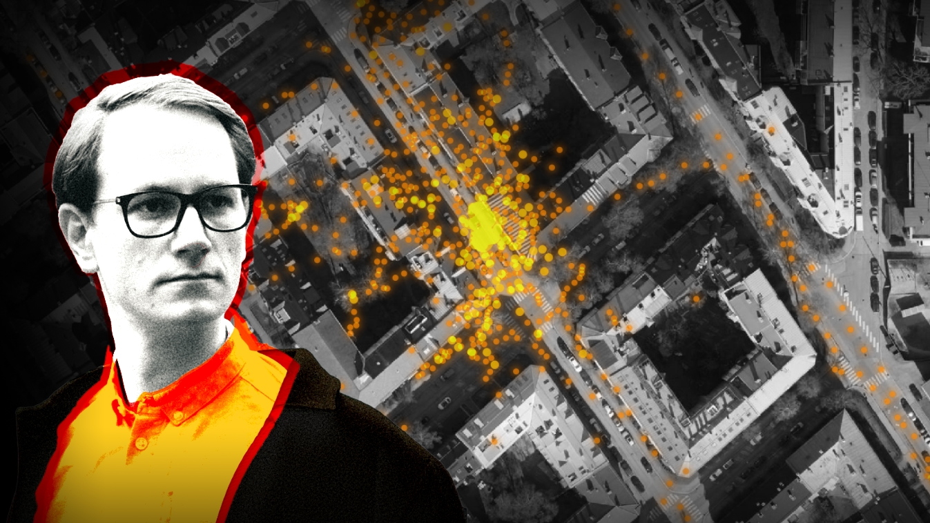
My Phone Was Spying on Me, so I Tracked Down the Surveillants
On August 20th, I requested a copy of all the information Venntel had about me. All Europeans have the right to do so, as a result of the GDPR, which was adopted in 2018.
The next day, the legal department of Venntel asked me to confirm some addresses I had visited recently.
“Once we have this information, we will first check to see if the Advertiser ID you provided is in our database,” the email said.
An «Advertiser ID» is something all smartphones have. This ID is the key to tracking phone users over time and across apps. Phone owners may limit how easy it is to access this ID, though few actually do.
I gave Venntel the address of my office at the NRK headquarters in Oslo, and to my flat at Majorstuen in Oslo.
Data for sale
Almost a month later, I received an interesting email attachment from Venntel. It contained information on where I’d been 75,406 times since 15 February. Suddenly I could retrace my every step – on a hike, out for a drink, and visiting my grandmother in Southern Norway.
DOTS: The left picture shows registrations of my movements in the area where I live. In the picture to the right, you’ll see a map of the NRK headquarters at Marienlyst. Over time, there have been an enormous number of registrations here. Illustration: Harald K. Jansson/Norge i bilderThere were no phone numbers or names in the data. Still, it would have been easy for nearly anyone to find out that this was me. Simple searches in Google and the white pages would show there was a Martin Gundersen living in Sorgenfrigata in Oslo and working at NRK Marienlyst.
#privacy #mobile #tracking #geolocation #data #datenschutz
https://nrkbeta.no/2020/12/03/my-phone-was-spying-on-me-so-i-tracked-down-the-surveillants/
3 Shares
I need to create a topographic map of land, started with the help of a gps tracker and an autoleved 360° laser. Unluckily the resulting gps points are not very accurate, so even though the tracks are partly 7m away from each other, they overlap heavily in the results. I tried to enhance the result with goiong the paths four times to build myself the "middle", but that didn't help as the results are even more conflicting.
I need help.. Is this even a good way to approach? Is this just how gps is or is it about my tracker thinking he schould create hiking paths?
On the picture are 6 tracks with each 2 rounds on the same path. I selected three of them, to show how much they overlap even though they are multiple meter away from each other.