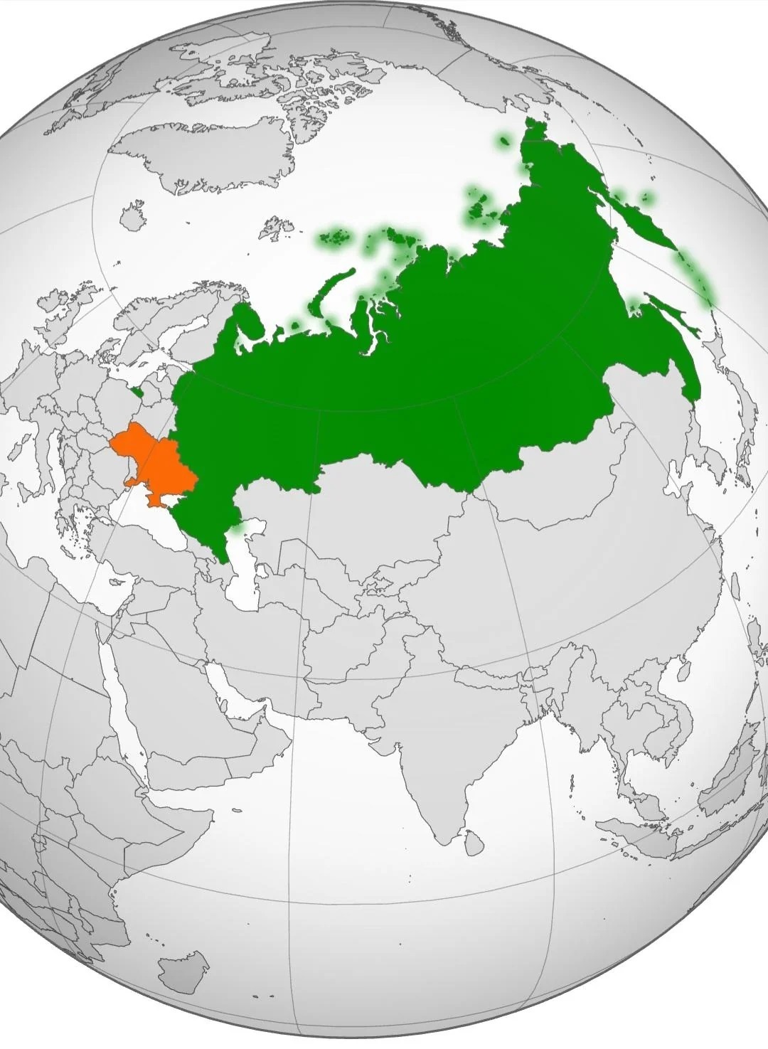
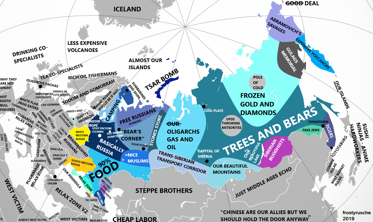
Russia and other countries according to Russians (2019)
https://mapsontheweb.zoom-maps.com/post/189489281501/russia-and-other-countries-according-to-russians
2 Likes
1 Shares
Russia and other countries according to Russians (2019)
https://mapsontheweb.zoom-maps.com/post/189489281501/russia-and-other-countries-according-to-russians

source: reddit
#usa #cars #map #information #parking #carculture
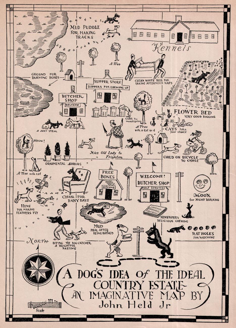
https://sciencemastodon.com/@oldmapgallery/113431242995831528 oldmapgallery@sciencemastodon.com - Can we do something lighter for today? The wonderful John Held Jr. and his map from c. 1930 of "A dog's idea of the ideal country estate" map.
John Held Jr was really an imaginative treasure of the time. Great illustrator and commentator on the culture of the time.
///Transiscope///
Transiscope’s goal is to raise the visibility of all the alternatives working for transition by collecting existing data and creating a single map to display the initiatives.
https://transiscope.org/alternatives-web-portal/
More open resources on https://libre.graineahumus.org
#Transiscope #portal #projects #transition #ecological #social #geolocation #resource #map
Highest denomination banknote issued by each European country
https://mapsontheweb.zoom-maps.com/post/730428217507348480/highest-denomination-banknote-issued-by-each

#europe history #economy #money #european #banknoten #crisis #map
https://mastodon.social/@pomarede/113250318469505867 pomarede@mastodon.social - Taylor Swift as a Basin of Attraction in the Local Universe
#TaylorSwift #Cosmology #Cosmography #Cosmicflows #Map #Universe #Laniakea #supercluster #laniakeasupercluster #galaxies #meme #science #memes #sciencememes #astrodon #swifties #popculture
Typical American (consumer) view of Ukraine
It’s quite evocative of how the US views Ukraine: as nothing more than an abject pawn to be moved around on the board in the great game for those “trillions” he’s salivating over.
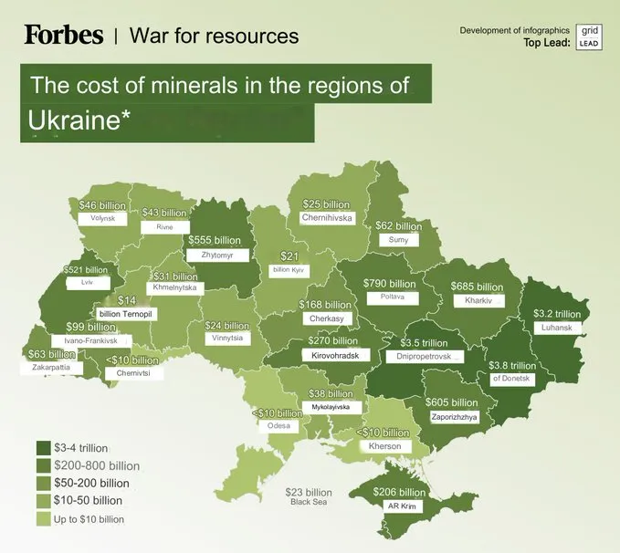
https://simplicius76.substack.com/p/sitrep-91024-european-antinomy-squeezes
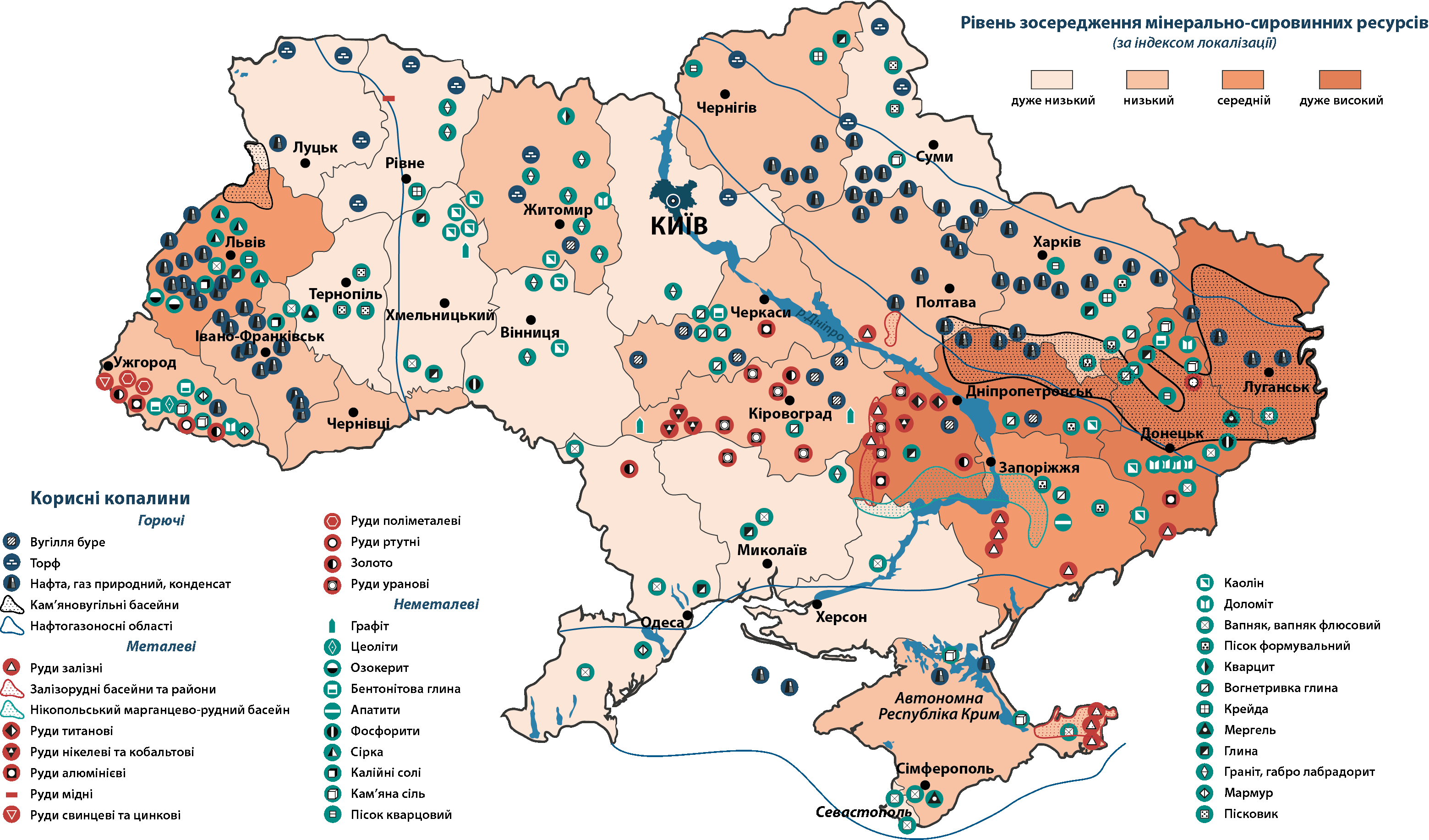
#USA #US #ukraine #ukrainian #map #minerals #resources #iron #coal #salt #blacksoil #american #money
As it's a #BankHoliday #weekend, we went on a hike on #Dartmoor. I planned it to be a visit to somewhere I hadn't been before but starting off from a familiar location. In total, the excursion was 18 km of walking and took the best part of 6 hours with all the stops and breaks. As anyone who has walked here before knows, it's not to be done without preparation and having a good #map and #compass with you is vital. Mobile phone reception is patchy at best and so I rely on a paper map and the tried-and-tested method of #DeadReckoning. Essentials include a pair of good quality #WalkingBoots, #WaterProof clothing available and you should always prepare to be colder than you would be in town. As the terrain is quite rough and the vegetation can be thorny along with the presence of insects, #Shorts are not recommended unless you're happy to have grazes and bites by the end of the trip. The elevation is between 400-500 m above sea level and it is one of the wettest places in #England. It is also exposed to high winds.
The start of the journey was easy enough, just a short climb up to a #Cairn.


Until you join a #path or #bridleway, you have to negotiate #gorse which, if you're not careful, could easily mean a twisted ankle. However, the wild #flowers are very colourful. You can also see part of #FernworthyForest in the background, which is where we were headed.


On the way to our first target, there were some #Neolithic artefacts such as these #StandingStones. There are some wild #DartmoorPonies in the background and I took a zoomed-in image of one of the ponies -- it's best not to get too close to them.


The first destination on the itinerary was #FernworthyReservoir. It has a #MasonryDam, which is not a common form of #Dam, most being concrete or earth (embankment) dams in the #UK. There is a another one in Dartmoor and so I'm guessing there was a trend to build such types at the beginning of the twentieth century, which is when I happen to know the other one was built. Neither the dam nor the #reservoir are very big but they do provide water for nearby populations.


The surface of the reservoir was quite choppy owing to the windy conditions. Also, the level was near the maximum and right up to spillway at the centre of the dam.


Fernworthy Forest is a #conifer forest, which I think is not natural, rather being there to provide timber. There are many track through it but none are marked and so the only way to find out which way you're going is to use a compass. I was uncertain of my precise location after a while but I knew that if we kept heading in a westerly direction, we'd eventually get to the other side.


Once out of the forest, it was a matter of heading south towards the main road. The weather forecast was spot on and it started to rain right on cue. Once over a rise, eventually we found a bridleway down.


Once we passed this #StoneCircle, I knew we were on the right track as it's marked on the #OSMap. The journey from there was quite straightforward, although still another 5-6 km to go.


The last leg of the journey was on a main road, without a separate footpath but just before getting onto that, I looked at the path we'd taken and also to the other side of Dartmoor.


#MyWork #MyPhoto #CCBYSA #DSLR #Nikon #D7000 #Summer #Countryside #Moorland
Situation in #Mali: Counter-Terrorism Operation in the North and Clashes in the Center of the Country
Summary for August 1 - 21, 2024
After strikes on Tin-Zaouaten, patrols in the surrounding areas have also become more active. The Malian army, supported by the Wagner PMC, conducted raids in some villages, where they found informants of militants and weapons. After reconnaissance, the convoys returned with prisoners.
▪️The center of the country - the Mopti region - is also restless. Along the "road of death" from Douentza to Gossi, there have been continued explosions targeting government forces' vehicles. Also, in the vicinity, an army convoy that was heading to Dialassagou was ambushed by #Islamists. 15 soldiers were #killed in the ambush.
▪️Reconnaissance is being conducted along the Mauritanian border to identify and eliminate militant cells. But the territory of Mauritania was again used by militants from the Al-Qaeda-affiliated group JNIM as a rear base for raids into Malian territory. Along the border, they attacked two army posts, from which the soldiers fled, leaving their weapons behind.
🔻All this once again underscores the problems of the Malian armed forces. Of course, the government is increasing the number of personnel, but due to the lack of officers, the effectiveness of the reinforcements is extremely low.
This problem directly affects our interests in the country. So, during a telephone conversation between the Foreign Ministers of Russia and Mali, Lavrov stated that Russian structures are ready to help improve the combat capability of the army. Most likely, this implies the deployment of the African Corps, which has been expected in the country for more than a month.

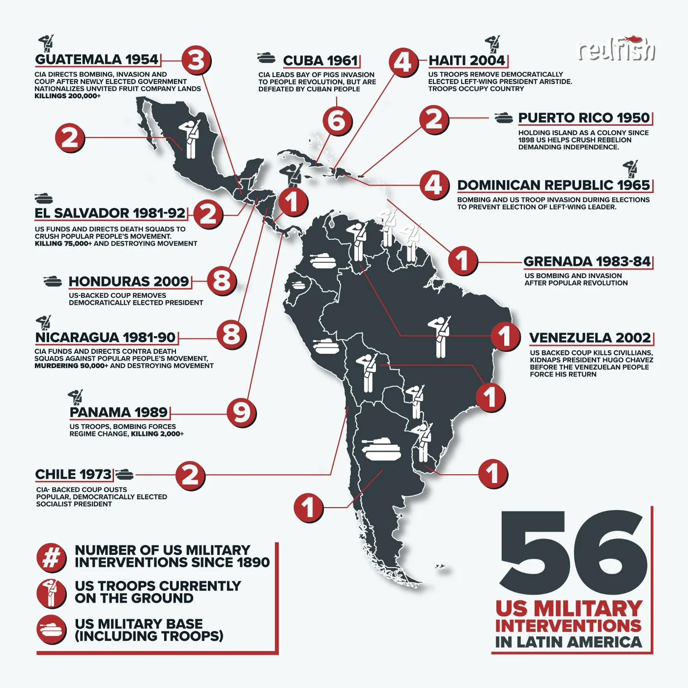
56 military interventions in Latin America alone..... and counting.
For "democracy" tho
#USA #US #CIA #MIC #Pentagon #military #deepstate #militarism #intervention #american #terrorism #democracy #map #history #latinoamerica


/cdn.vox-cdn.com/uploads/chorus_asset/file/25472454/STK270_GOOGLE_MAPS_D.png)