
#siberia
Russia: Ural Airlines plane emergency lands in Siberia, all passengers survive
The crew of a Russian airliner are being hailed as heroes for miraculously emergency landing in a field in Siberia. All 165 passengers and crew were unharmed...#A320 #Airbus #Europenews #FlightU61383 #RA73805 #Russia #Russialatestnews #Siberia #Uralairlines #aviationaccidents #aviationnews #crashlanding #emergencylanding #flightradar #forcedlanding #narrowbodyairbus #omsk #planecrashes #sochi #uralairlinesemergencylanding #AlJazeera #AlJazeeraEnglish #alJazeera #aljazeeraEnglish #aljazeeralive #aljazeeravideo #aljazeeraEnglish #aljazeeralatest #aljazeeralive #aljazeeralivenews
Russia: Ural Airlines plane emergency lands in Siberia, all passengers survive
Worms #Frozen for 46,000 Years are the Oldest Known Living Animals
source: https://www.the-scientist.com/news-opinion/worms-frozen-for-46-000-years-are-oldest-known-living-animals-70048
more: https://www.biorxiv.org/content/10.1101/2022.11.10.515937v1
After years of studying the genetics and morphology of the long-frozen nematodes, Shatilovich and her colleagues now claim that the reanimated worms are a previously-undescribed species—one from 46,000 years ago, making them the oldest living animals on the planet.


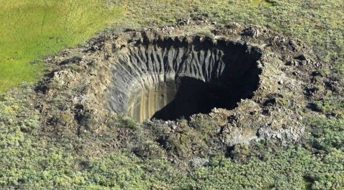
Massive holes forming in Siberian permafrost
Methane beneath or within ice-rich permafrost can create mounds at the land surface. Once over-pressurized by methane, these mounds can explode and eject frozen ground, forming a gas emission crater (GEC).

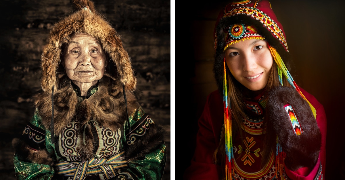
A neat collection of photographs showing the various peoples of Siberia.
#photography #Siberia #indigenous
https://mymodernmet.com/alexander-khimunshin-indigenous-people-siberia/
● NEWS ● #meduza #ru #russia #MikhailFedyayev #Siberia ☞ ‘A mix of schadenfreude and fear’ The arrest of one of Russia’s richest men following a deadly mine explosion has pleased locals but raised worries about regional stability https://meduza.io/en/feature/2021/12/31/a-mix-of-schadenfreude-and-fear
● NEWS ● #meduza #ru #russia #Siberia ☞ Defendant number nine Russia jails prominent businessman #MikhailFedyaev in connection with deadly mine accident in Siberia https://meduza.io/en/feature/2021/12/16/defendant-number-nine
‘Spirit of Altai’ Showcases the Expansive and Diverse Beauty of Siberia
![]()
Filmmaker Vadim Sherbakov has created a short aerial film called "Spirit of Altai," exclusively shot with DJI Air 2S drone that showcases the beautiful landscape of a West Siberian region in Russia.
Prior to the pandemic, Sherbakov generally traveled outside of his home country of Russia to capture incredible locations, but the last couple of years has changed his perspective and he has begun to focus on and appreciate the picturesque landscapes at his own doorstep.
Earlier this year, Sherbakov shared "The Noor" -- a short film dedicated to the raw beauty of frozen Baikal lake in the Eastern Siberia region of Russia. This time, Sherbakov has turned his drone to an equally as picturesque region in Altai in Western Siberia. In "Spirit of Altai," he swapped the vastness of ice for a diverse landscape that spans mountains, rivers, forests, deep blue lakes, and wavy roads.
![]()
Sherbakov had only seen images of the region and hadn't visited it before the shoot as it is a ten-hour drive away from his home. He tells PetaPixel that the region had been on his wish-list and it didn't disappoint when he got to experience it.
![]()
![]()
![]()
Though he is not a stranger to challenging shooting conditions, Sherbakov experienced some filming difficulty due to extremely strong winds in a couple of locations.
"I had six days to explore the region and not every day was great," he says. "Due to weather and particularly low clouds, we could not travel to one or two planned locations. Also, I got sick on the fourth day because of hyperthermia and missed an amazing morning shoot with low fog (once in a million opportunity as I have been told) but I didn't get upset since I think I went home with great material."
![]()
![]()
![]()
Sherbakov shot the film by himself whilst on a trip which was a part of a photo tour with ten other travelers. During the post-production stage, he teamed up with a composer to produce unique and authentic sound material.
![]()
![]()
![]()
![]()
This film is a positive outcome of an otherwise difficult situation. Because Sherbakov was not able to travel abroad due to pandemic restrictions, he is glad that he has been able to turn to appreciate what his own country has to offer. He also hopes that the film will showcase the grand beauty of the region and immerse the audience.
More of Sherbakov's work can be found on his website, Instagram, YouTube, and Vimeo.
Image credits: Photos by Vadim Sherbakov.
#inspiration #spotlight #travel #aerial #cold #dji #djiair2s #drones #dronevideo #mountains #russia #shortfilm #siberia #vadimsherbakov
So YouTube put a video about #siberia on my frontpage yesterday and then I watched two from this channel:
https://www.youtube.com/channel/UCewnpz5mc4Sjx4esAs54O0w
I mean usually I neighter have the time nor the nerves to watch films or videos at all - but her style is okay, some modern effects, yes, but not too hectic. Also interesting stuff about #china and different cultures.
Will watch some more later: Seeing freezing cities always makes me feel warm here ;)
Mysteries of massive #holes forming in Siberian #permafrost unlocked by scientists
source: https://edition.cnn.com/2021/02/17/world/siberia-craters-arctic-climate-change-scn/index.html
The craters are thought to be linked to #climate change.
#Siberia #warming #environment #future #warming #mystery #news
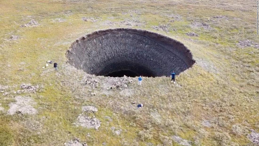

Photo by Stas Bartnikas @stasbart / Located in Russia's Altay region, Mount Belukha is the highest mountain in Siberia at 4,506 meters (14,783 feet). This place is believed to have the strongest energy in all of Altay. Mystics say that the entrance to Shambhala, the place where the teachers of mankind lived, is located here. Well, it feels that way. It was a challenging flight. At 3,900 meters altitude, we practically reached the limit for a Robinson R44 helicopter, with strong winds, the door removed, the cold. [+]
Here's another shot from wikipedia...


● NEWS ● #CommonDreams ☞ From #California to #Greece to #Siberia , #Wildfires Rage Worldwide—and More Expected https://www.commondreams.org/news/2021/08/11/california-greece-siberia-wildfires-rage-worldwide-and-more-expected
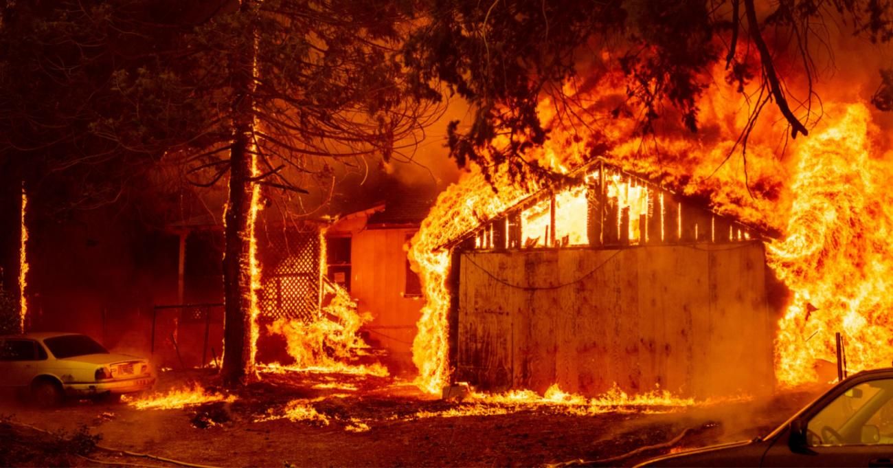


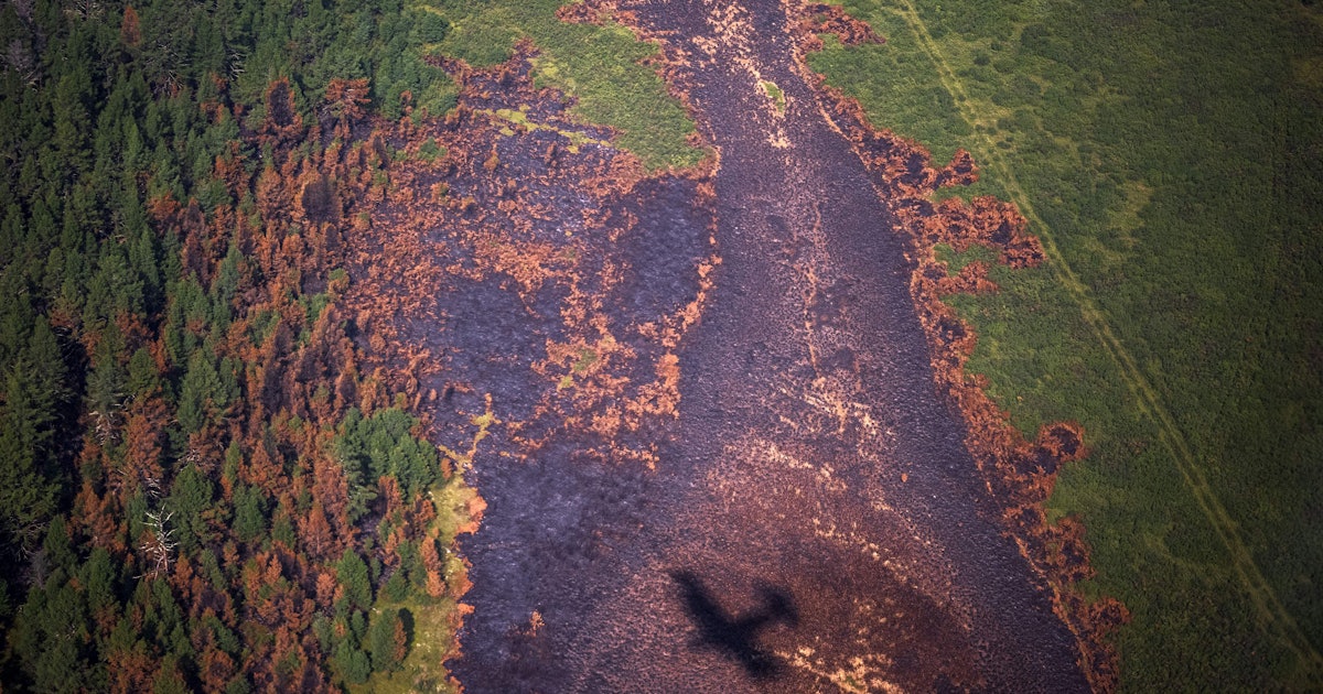

● NEWS ● #CommonDreams #RUSSIA ☞ #Siberia Faces 'Airpocalypse' as Unprecedented #Wildfires Engulf Region in Toxic Smoke https://www.commondreams.org/news/2021/07/21/siberia-faces-airpocalypse-unprecedented-wildfires-engulf-region-toxic-smoke
