2 Likes
2 Shares
It's bad enough that wildfires are driving up the price of lumber and the droughts have already driven up the price of food, but hey--what's another wildfire burning up most of our wheat, corn & other grain production too.
♲ Dragofix - 2024-11-03 17:11:53 GMT
If Trump dismantles the NOAA, it will affect wildfires and food prices #UnitedStates #USA #US #environment #wildfire #wildfires #food #NOAA #politics #USpol #Trump arstechnica.com/science/2024/1…
Fascinating Mechanical Computer
#History #Technology #NOAA #BreakfastVideo
#canicule #océan #atlantique #mortalité-massive #espèces-marines #environnement #climat #température #noaa #effet-de-serre #el-niño #coraux
https://www.theguardian.com/environment/2023/apr/06/greenhouse-gas-emissions-noaa-report-us-data
#Pollution #Environment #GlobalWarming #ClimateChange #FossilFuels #NOAA
● NEWS ● #CommonDreams #NOAA ☞ 'Wake-Up Call': NOAA Predicts One-Foot Sea-Level Rise by 2050 https://www.commondreams.org/news/2022/02/15/wake-call-noaa-predicts-one-foot-sea-level-rise-2050
● NEWS ● #ABC #Environment ☞ US coastlines to experience 'profound' sea level rise by 2050: #NOAA report https://abcnews.go.com/International/us-coastlines-experience-profound-sea-level-rise-2050/story?id=82884816
● NEWS ● #CommonDreams #NOAA ☞ 'Terrifying' Hot Streak Continues as NOAA Says 2021 6th Warmest Year on Record https://www.commondreams.org/news/2022/01/13/terrifying-hot-streak-continues-noaa-says-2021-6th-warmest-year-record
● NEWS ● #NOAA #Environment ☞ Arctic Report Card 2021: Rapid and pronounced warming continues to drive the evolution of the Arctic environment https://arctic.noaa.gov/Portals/7/ArcticReportCard/Documents/ArcticReportCard_full_report2021.pdf
● NEWS ● #CommonDreams ☞ US Breaks Summer Heat Record Set During Dust Bowl in 1936: #NOAA https://www.commondreams.org/news/2021/09/10/us-breaks-summer-heat-record-set-during-dust-bowl-1936-noaa
● NEWS ● #CommonDreams ☞ Experts Warn #NOAA Plan Might 'Delay' Right #Whales #Extinction , But Not Save Them https://www.commondreams.org/news/2021/08/31/experts-warn-noaa-plan-might-delay-right-whales-extinction-not-save-them
● NEWS ● #TruthOut #NOAA ☞ Greenhouse Gases and Sea Levels Shattered Global Records in 2020, Says NOAA https://truthout.org/articles/greenhouse-gases-and-sea-levels-shattered-global-records-in-2020-says-noaa/

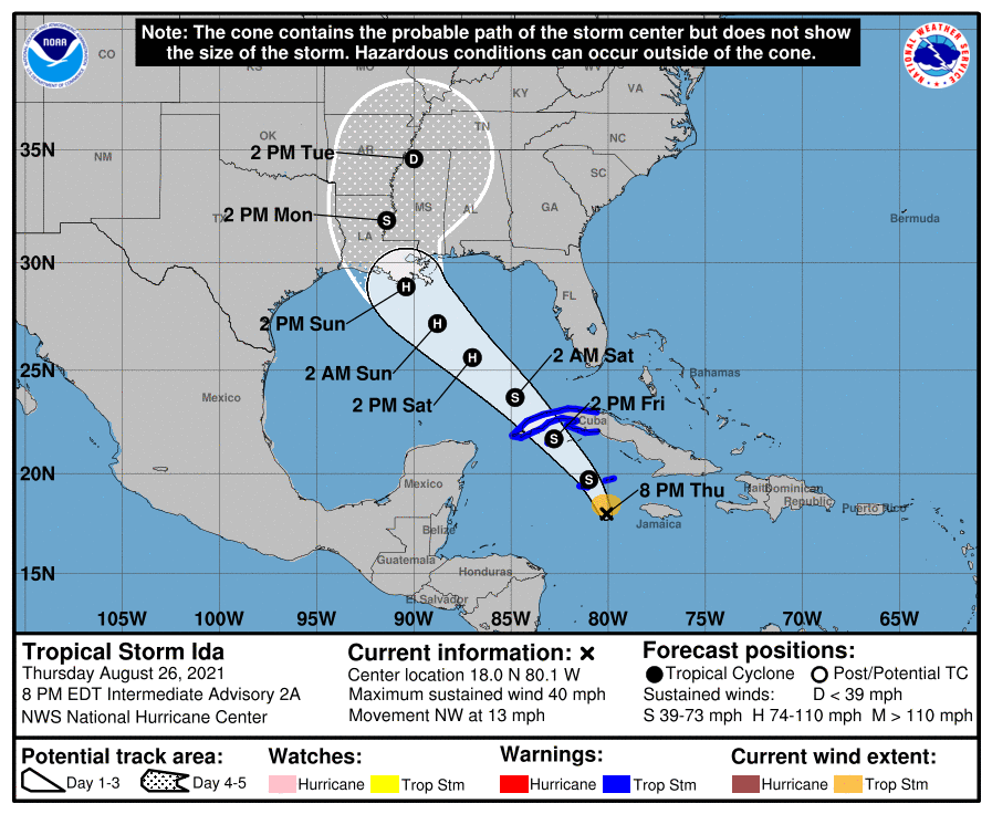
Tropical Storm Ida is expected to make landfall on the Louisiana coast at Grand Isle as a strong Category 2 hurricane Sunday afternoon, pushing the Gulf of Mexico into coastal areas and dropping extremely heavy rain far inland. The storm will then head north and northeast towards Baton Rouge and Monroe.
It's the most serious weather threat to Louisiana of the 2021 Atlantic Basin hurricane season, after a record-breaking 2020 that saw four named storms - including Category 4 Hurricane Laura - strike the state. It's predicted landfall would bring it ashore on the 16th anniversary of Hurricane Katrina, the costliest storm in U.S. history.
https://www.nola.com/news/hurricane/article_0dd9a3d8-06a3-11ec-8b3e-ef7a2e559634.html
Tropical Storm Ida is forecast to arrive at New Orleans, LA about noon--2pm Sunday (local time), at hurricane strength.
The cone of probability is relatively narrow, though landfall locations could still vary considerably. Intensity is likely to be high given high Gulf sea temps.
Louisiana is also seaing an all-time peak Covid infection rate.
US National Hurricane Center:
https://www.nhc.noaa.gov/refresh/graphics_at4+shtml/234304.shtml?cone#contents
Ida looks to be slow-moving and will remain over or upstream of New Orleans for 18--48 hours, with rain intensities of an inch an hour (25.4 mm/hr), which could be over 18--36 in (500 -- 1000mm) of rain.
Nullschool Arrival Forecast at noon CST, with 968 hPa, winds are hard to say (Nullschool's forecasts run low, stated is 70 mph, could exceed 110 mph), and 97mm/3hr rain (3.83 in/3hr). I also don't get storn surge, though the eye looks as if it may pass very slightly west of NoLa, which means that the storm surge on the east of the city will be amplified.
This could be a major storm.
There does not appear to be any other Atlantic tropical storm threat at this time.
#TropicalStorms #Hurricane #HurricaneIda #NewOrleans #covid19 #noaa #weather #NoaaNHC
● NEWS ● #CommonDreams ☞ Atmospheric #CO2 Levels Haven't Been This High in 800,000 Years: #NOAA https://www.commondreams.org/news/2021/08/25/atmospheric-co2-levels-havent-been-high-800000-years-noaa