
One person like that
#gis
LUC on Twitter: "14. 'Hexagons' Yesterday's entry for the #30DayMapChallenge was made by Laura from our #GIS team 🗺️ Her map displays the #landuse and occupation of #Ukraine in the distinctive, hexagonal boardgame style of #Catan 🎲 #GISchat #maps #mapping #boardgame #tabletopgaming https://t.co/EvqaUQ1yEq" / Twitter
Impressive!
https://nitter.it/LUCtweeting/status/1592472909653708802
https://twitter.com/LUCtweeting/status/1592472909653708802
14. 'Hexagons'
— LUC (@LUCtweeting) November 15, 2022
Yesterday's entry for the #30DayMapChallenge was made by Laura from our #GIS team 🗺️
Her map displays the #landuse and occupation of #Ukraine in the distinctive, hexagonal boardgame style of #Catan 🎲#GISchat #maps #mapping #boardgame #tabletopgaming pic.twitter.com/EvqaUQ1yEq
5 Likes
2 Comments
Julian Hoffmann on Twitter: "Carte des vins de France 🍷🇫🇷 | #30DayMapChallenge Day 11 - Red - Experimental map v1. Made in #Blender3d . #dataviz #maps #wine #vin #gis #b3d #MadeInFrance https://t.co/UGHb9Ll1lP" / Twitter
Wow that looks fantastic!
https://nitter.it/Julian_H0ffmann/status/1591005631707766785
https://twitter.com/Julian_H0ffmann/status/1591005631707766785
Carte des vins de France 🍷🇫🇷 | #30DayMapChallenge
— Julian Hoffmann (@Julian_H0ffmann) November 11, 2022
Day 11 - Red - Experimental map v1. Made in #Blender3d . #dataviz #maps #wine #vin #gis #b3d #MadeInFrance pic.twitter.com/UGHb9Ll1lP
5 Likes
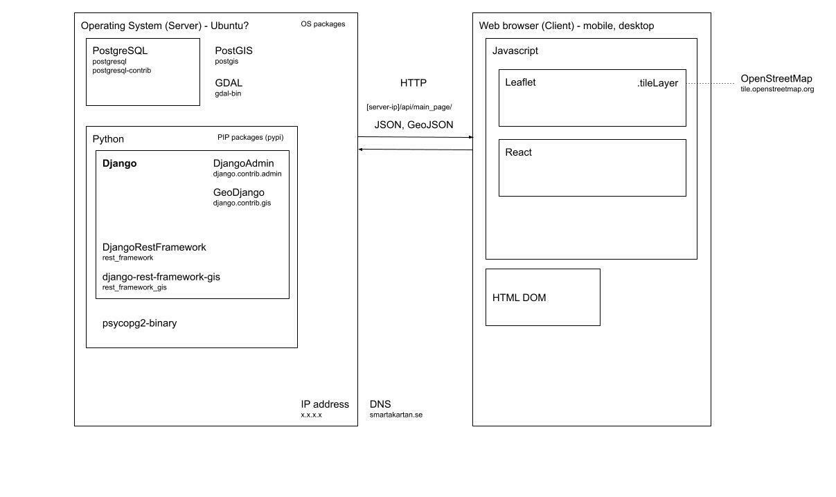
Feedback on map website architecture
Hi all, i'm now doing work training for an organization who has a map website showing people environmental-friendly places around cities in Sweden (and potentially the world)
I'd like to ask you for some feedback on the architecture that we are looking at using for version 4 of the website
The current website, version 3 is live here: https://www.smartakartan.se/en/
In brief, these are the core requirements:
* Storing map points in a database
* Displaying map points to the end users
* Adding map points (and other data) in an admin interface
* Exposing API so that others can read our data
Gitlab repo: https://gitlab.com/kollaborativ-ekonomi/smartakartan4
Drawing of overview: https://docs.google.com/drawings/d/15sx4YFCvtGF8nAua7IqMI7zYry7YVGBZa7iAJvCffBQ/edit?usp=sharing
Any and all feedback is welcome!
#web-development #software-architechture #gis
@Christoph S @Christoph S @Christophe Riolo @Hank G
3 Likes
4 Comments
Hey everyone, I’m #newhere. I’m interested in #arduino, #chiptune, #dubstep, #electriccars, #electricvehicles, #esri, #ev, #gis, #legendofzelda, #linux, and #tesla.
CartNat : Une Cartographie du gradient de naturalité potentielle de France métropolitaine

Le projet CartNat vise à développer une méthode de cartographie de la naturalité potentielle. Ces travaux ont abouti en 2021 pour la France métropolitaine terrestre et les cartographies produites consistent en 4 couches spatiales :
- L’intégrité biophysique de l’occupation du sol
- La spontanéité des processus
- Les continuités spatiales
- La carte synthétique du gradient de naturalité potentielle à partir des critères 1 à 3
Les cartographies sont aujourd’hui mises à disposition (format ESRI Geodatabase – 2.3 GB) et la notice technique qui les accompagne décrit la méthodologie appliquée.
#uicn #cartographie #sig #naturalité #nature #wilderness #mapping #gis #france #géographie #geography
One person like that
1 Comments
1 Shares
Coronavirus: Seniors cut off from income supplement after receiving emergency benefits
In a letter sent to three Liberal cabinet ministers, NDP MP Daniel Blaikie said many seniors who received the CERB and Canada Recovery Benefit either do not qualify for the guaranteed income supplement or face drastic deductions to it.
#CERB #seniors #GIS #politics #cdnpoli

One person like that
1 Shares
OpenStreetMap looks to relocate to EU due to Brexit limitations | Brexit | The Guardian
OpenStreetMap, the Wikipedia-for-maps organisation that seeks to create a free and open-source map of the globe, is considering relocating to the EU, almost 20 years after it was founded in the UK by the British entrepreneur Steve Coast.
OpenStreetMap Foundation, which was formally registered in 2006, two years after the project began, is a limited company registered in England and Wales. Following Brexit, the organisation says the lack of agreement between the UK and EU could render its continued operation in Britain untenable.
3 Likes
1 Comments
