#hiking

aga@diasp.org

Kuh in Bayern. 🐂🐄
Die Kuh graste an einem Golfplatz ⛳️ in der Nähe von Fuschlsee. Leider die Gastwirtschaft Hütte öffnet erst am 1. April! So blieb uns nichts anderes übrig, als weiter wandern gehen und erst auf dem Rückweg in Fuschl eine Kaffee und Kuchen Pause einlegen. Nur zur Erinnerung habe ich die paar Fotos mit der bunten Kuh geknieppst. 😀😉👋

#Natur #Frühling #Wanderung #Fuschlsee #Erinnerungen #Kuh #Foto #meinFoto #mywork #Nature #Spring #Hiking #Fuschlsee #Memories #Cow #Photo #myPhoto

danie10@squeet.me

Trail Sense: Android Open-Source app for entirely offline use for hiking, backpacking, camping, and geocaching

In background a blurred image of a mountain, and in foreground is title text saying Trail Sense for Navigation, Weather and Astronomy
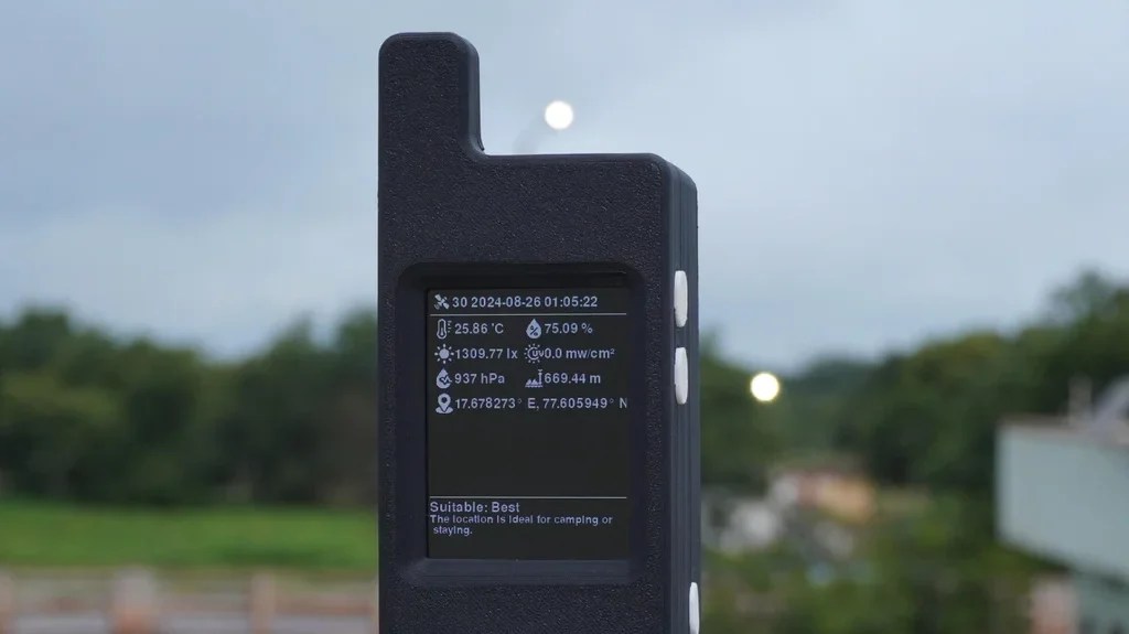
Trail Sense is a tool, and just like any other tool that you bring into the wilderness, it’s essential to have backup equipment and skills. One of its goals is that its features should make use of the sensors on a phone rather than relying on stored information such as online guides.

Features:

  • Designed for hiking, backpacking, camping, and geocaching
  • Place beacons and navigate to them
  • Follow paths
  • Retrace your steps with backtrack
  • Use a photo as a map
  • Plan what to pack
  • Be alerted before the sun sets
  • Predict the weather
  • Use your phone as a flashlight
  • Estimate height of a cliff
  • And much more!

So you’ll notice with this app there is no quick download of some map or guide. The idea is to prepare before departing with photos of your map, putting waypoints in, etc.

See https://github.com/kylecorry31/Trail-Sense
#Blog, #hiking, #opensource, #technology, #trails

z428@loma.ml

Zurück in bewohntem Gebiet. Regen trocknet in Haaren und Kleidern. Dämmerung als Farbton und Gefühl. Ein kleiner Gastraum, die 1980er haben sich in den Boxen verfangen, das Bier ist kalt und herb. Hier atmet vieles Erinnerung, und an manches knüpft man nicht mehr an. (Kommt man zur Ruhe, ist eine gewisse Erschöpfung spürbar. Und die Bilder des Tages sinken langsam ein.)

#outerworld #the_baltic_self #escapism #hiking

#the baltic self

robbie@diaspora.ragesoss.com

Hey everyone, I’m #newhere. I’m interested in #blogging, #camping, #hiking, #school, and #sport-shooting.

Everyone I know is on #Facebook but God, it's awful! All ads, lots of political stuff, and lots of narcissistic "Ain't I cute? Here's another picture of me being cute!" I want to make a blog maybe, and talk about more interesting things. I'm not like most other kids I guess, and Facebook isn't a good place to blog or be taken seriously. I hope there are other kids here to make friends with.

I read about #Diaspora being the easiest platform for new people in the #Fediverse to learn so here I am trying out Diaspora.

jirikiha@diasp.org

Today's #hike was from the Pima Canyon Trailhead to the tunnel. Basically a path under some rocks that haven't fallen yet, it's a cool place to rest. It looks wet, but that's just the polish from innumerable hikers brushing past. I didn't expect to get that far but my hiking partner had a goal and I was feeling up to it. It's about a mile further in than we usually go but the weather was cool, about 80f so it was easier than usual.
I was out of my main water by the time we returned to the start. Memo to me: bring more next time. I had a reserve bottle in my pack so wasn't in any danger. There's also a thermos of ice water in the car. Never skimp on water #hiking in Arizona. Even when it's cool the dry air sucks the moisture from your body faster than you can imagine.
This hike was 7 miles, give or take. The geology got more interesting further in. I wish I knew more about it.

lmsvater@friendica.a-zwenkau.de

Die Wasserfälle des Kaltebornebachs bei Bad Wildungen-Odershausen.

Der #Kaltebornebach kurz bevor er zwischen #Helenenquelle und #Talquelle in den #Sonderbach mündet:

#myphoto, #BadWildungen - #Odershausen, #FürstentumWaldeck, #Nordhessen

#Foto, #photo, #Natur, #nature, #Wasserfall, #Bach, #Wald, #forest, #Wandern, #hiking, #Radtour, #Fahrrad, #biking, #Quellenrundweg, #Ederradweg, #Hessen, #fedibikes, @fedibikes_de group, @fedibikes group

lmsvater@friendica.a-zwenkau.de

Der Himmel über dem Hasenberg.


#myphoto, #DaLiegtDerFels, #TourDeChattengau

Auf dem #Hasenberg, einer 4 km vom #Wartberg entfernten und zwischen den Fritzlarer Stadtteilen #Haddamar, #Lohne und #Züschen gelegenen 304 m hohen #Basaltkuppe, befand sich eine späte jungsteinzeitliche Höhensiedlung, die der #Wartberg-Kultur zugeordnet wird. Gefunden wurden insbesondere Pfeilspitzen, die im Regionalmuseum in #Fritzlar ausgestellt sind. https://de.wikipedia.org/wiki/Hasenberg_(Lohne)

Der #Hoheberg, 2100m vom Hasenberg entfernt und 376 m hoch:

#Foto, #photo, #Abendrot, #BlaueStunde, #Basalt, #Basaltkegel, #Natur, #nature, #Archäologie, #archeology, #Vorgeschichte, #Prehistory, #Steinzeit, #StoneAge, #Jungsteinzeit, #Neolithikum, #Neolithic, #Wandern, #hiking, #Radtour, #Fahrrad, #biking, #Chattengau, #Schwalm-Eder-Kreis, #Nordhessen, #Hessen, #fedibikes, @fedibikes_de group, @fedibikes group

lmsvater@friendica.a-zwenkau.de

In der Mitte der #Wartberg bei #Kirchberg in #Nordhessen, ein #Basaltkegel / eine #Basaltkuppe und Namensgeber der #Wartberg-Kultur (3500 v. Chr. bis 2800 v. Chr.). Halb rechts hinten der Niedensteiner Kopf.


#myphoto, #DaLiegtDerFels, #Chattengau, #TourDeChattengau,
https://de.wikipedia.org/wiki/Wartberg-Kultur

Der Philosoph, er weiß es nicht zu fassen,
Da liegt der Fels, man muss ihn liegen lassen.

#FaustByGoethe 2, Vers 10113, 10114

Zu BlauerStunde:

#Abendrot:

#Foto, #photo, #Basalt, #NiedensteinerKopf, #BlaueStunde, #Natur, #nature, #Wandern, #hiking, #Radtour, #Fahrrad, #biking, #ChattengauRadweg = #R21 #Hessen, #fedibikes, @fedibikes_de group, @fedibikes group

danie10@squeet.me

Don’t just blindly trust your mobile phone app when hiking or trail running around Cape Town, do these things as well!

A red rescue helicopter hovering in the foreground with someone looking down from the open hatch, and mountains in the background
Lesser used paths are often very difficult to follow, and a wrong turn can lead you quickly into difficulties, or even plunge off a 100+ metre drop, especially on Table Mountain. So do some extra research and planning before setting out for the first time on a new trail.

Always research a route also on something like Google Maps that will show the contours, distances, places close by, and often photos and reviews. You can also try the 3D view, or else revert to Google Earth for that.

I’d also highly recommend a well-used app like AllTrails that shows not only recent reviews, but also gives an idea of how often a trail is in use. It also has a good side-view of the elevation along the trail. If you are not familiar with the area, try stick to busier routes like the Newlands Forest Trails or Kirstenbosch Gardens if you are on your own. AllTrails as well as Strava (both maybe premium I think) as well as Google Maps will allow you to share your location as you are moving. Privacy is absolutely not a consideration when out hiking or being on a trail run.

Safety against nature is only one consideration, and the other is unfortunately against humans. We’ve had a few instances of muggings, and even murder, in Cape Town so it is not recommended at all that especially non-residents go out alone on lesser used trails, or over the top of Table Mountain where there is little cellphone reception. Always try and hike or run with someone else, try stay within cellphone reception areas, and let others know where you are going, and when you expect to return.

Apps such as Casi cost only about $2 pm and can summon armed response to assist you. You can also consider installing an app (or automation app like Tasker or MacroDroid) that alerts you if cellphone reception has been lost.

If you’re a ham radio operator, carry your VHH/UHF radio with you as you can summon help on 145.700 or 145.750 FM from most areas where there is no cellphone reception, and rescue organisations such as WSAR often have a ham radio operator on board. If your radio has APRS beaconing, keep that on as your location will be pinpointed at all times.

If you feel lost or threatened, rather summon help quickly and at least have someone monitoring you, than leave it too late (even if this is the BnB owner you are staying with).

There are some really great nature and trails to be explored around Cape Town, but it is essential to be prepared before going out. It is absolutely not to be considered a “walk in the park”.

Make sure your phone battery is fully charged, you have some clean drinking water, a good hat, a jacket, and ideally also have mobile data available. Also check the weather reports before leaving, and remember that in strongish winds the cable car station closes (as I discovered one day and had to descend Table Mountain in the dark).

See https://www.capetownetc.com/news/wsar-rescues-trail-runner-in-jonkershoek-nature-reserve/
#Blog, #capetown, #hiking, #safety, #technology

lmsvater@friendica.a-zwenkau.de

Der #Scharfenstein ein #Basaltkegel und #Naturdenkmal bei #Dissen in #Nordhessen


#myphoto, #HierLiegtDerFels_No. 1, #Gudensberg - Dissen, #Chattengau, #TourDeChattengau
https://de.wikipedia.org/wiki/Scharfenstein_(Hessen)

Der Sage nach soll eine Jungfrau einen im Inneren des Scharfensteins verborgenen Schatz behüten. Sie tritt alle sieben Jahre hervor und niest siebenmal; wer ihr siebenmal „Gott helf!“ zuruft, gewinnt den Schatz und die Jungfrau. Einst hörte sie ein Fuhrmann niesen und erwiderte ihr sechsmal „Gott helf!“ Als er aber beim siebten Mal ungeduldig stattdessen einen Fluch ausrief, verschwand die Jungfrau für immer.
( https://de.wikipedia.org/wiki/Scharfenstein_(Hessen) )
Ich kann das bestätigen. Sie kam nicht. 🙁

Der Philosoph, er weiß es nicht zu fassen,
Da liegt der Fels, man muss ihn liegen lassen.

#FaustByGoethe 2, Vers 10113, 10114

#Foto, #photo, #Basalt, #Natur, #nature, #Wandern, #hiking, #Radtour, #Fahrrad, #biking, #ChattengauRadweg = #R21 #Hessen, #fedibikes, @fedibikes_de group, @fedibikes group

#HierLiegtDerFels No