
One person like that
#citizenscience
3 Likes
One person like that
6 Likes
1 Comments
2 Likes
1 Shares
One person like that
2 Shares

One person like that
4 Likes
2 Shares
2 Likes
One person like that
2 Shares
One person like that
1 Shares
How The Hunga Tonga Volcano Eruption Was Felt Around The World

On the 14th of January, 2022, the Hunga Tonga-Hunga Ha'apai volcano began a gigantic eruption that would go on to peak in ferocity the next day. The uninhabited island volcano would quickly make headlines as the country of Tonga was cut off the world and tsunamis bore out from the eurption zone.
In a volcanic event of this size, the effects can be felt around the world. With modern instruments, they can be properly understood too. Let's take a look at how the effects of the Hunga Tonga eruption were captured and measured across the globe.
Far-Flung Effects
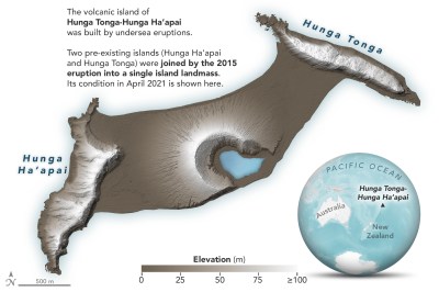 The state of the Hunga Tonga-Hunga Ha'apai island in April 2021. Credit: NASA
The Hunga Tonga-Hunga Ha'apai volcanic island that erupted in January bears two names because it was originally two separate islands that had become connected by volcanic activity back in 2015, so you know this is a geologically active region. However, the eruption this time was so ferociously powerful that the island was almost entirely destroyed, with satellite images taken in the aftermath shown only a small segment of high ground remains in the area.
In the wake of the event, NASA reported that the eruption was hundreds of times more powerful than the atomic bomb dropped on Hiroshima in World War II, roughly the equivalent of 4-18 megatons of TNT. Ash was sent high into the atmsophere, potentially up to a height of 50 kilometers, to the point where the cloud could readily be photographed by astronauts on the ISS.
Sensors Everywhere
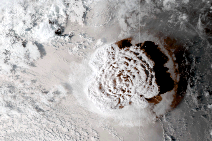
 The pressure wave from the Tonga eruption as captured by the NOAA's GOES-WEST satellite's infrared radiance data. Animation credit: Mathew A Barlow, University of Massachusetts Lowell, usage approved with attribution
However, one needn't have the instruments and infrastructure of a national space program to detect such a large event. One [Edward Jensen] reports that his own weather station in Phoenix, Arizona captured a pressure anomaly from the eruption, as did other amateur weather installations in the area. This could be dismissed as an anomaly, of course, but the data checks out.
In fact, with pressure altimeter readings from national meteorological networks collated by [Daryl Herzmann], one can clearly see the pressure wave from the eruption passing over the continental United States on the afternoon of January 15. The National Weather Service also concurs with their own analysis, showing how the pressure wave reached stations as far-flung as Salt Lake City, Utah and Glasgow, Montana. Effects weren't just seen in wiggling graphs of weather data either; the volcano was credited with lifting the fog in Seattle as the pressure wave passed by.
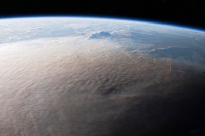 Ash from the eruption was lofted high into the atmosphere. This photo of the eruption was taken from the International Space Station. Credit: NASA
Distributed networks of sensors are particularly useful for tracking events like these; we've attempted to use similar methods ourselves to investigate nuclear incidents, albeit without success. Incidentally, though, the powerful blast of the Hunga Tonga eruption was picked up at all 53 infrasound monitoring stations maintained by the Comprehensive Nuclear Test Ban Treaty Organisation, highlighting that the event really was on the scale of a nuclear detonation.
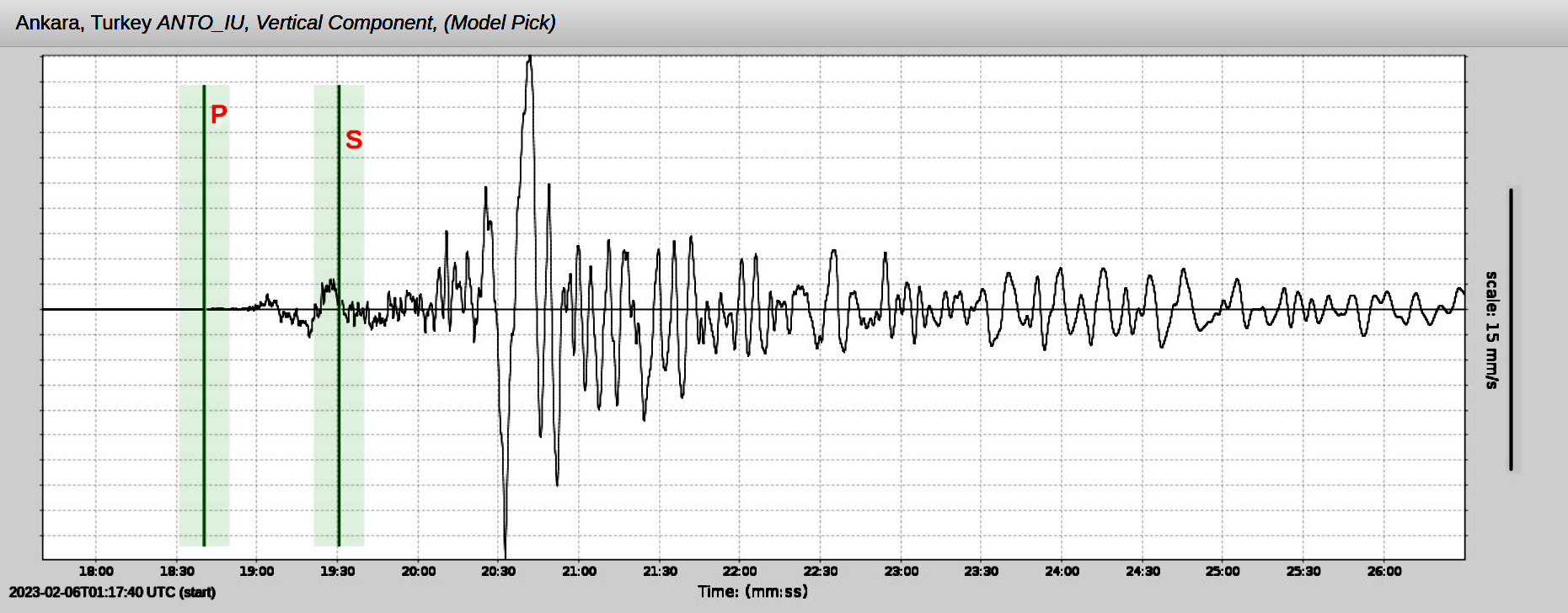
Earthquake sensors were able to pick up the rumblings from the eruption, as you'd expect. The US Geological Survey released images on Twitter showing how seismographs at Mount Hood, Oregon recorded the event. Meanwhile, tsunami warning systems were triggered around the Pacific. Studies suggest that while tusnami waves were detected on many shores far from Tonga itself, such as in Peru and Japan, these were likely generated by the interaction of the atmospheric pressure wave with the water, rather than being generated by earthquake events themselves.
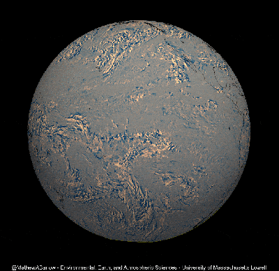
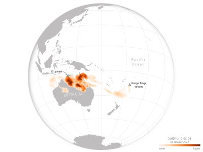 Data captured by the ESA's Copernicus Sentinel-5P pollution monitoring satellite showed sulfur dioxide released from the eruption passing over Australia in the days after the event. Credit: ESA, CC BY-SA 3.0
Outside of the waves from the event, other lingering effects from the volcanic activity have spread around the world. The Copernicus Sentinel-5P mission captured a giant sulfur dioxide plume from the eruption which had floated its way over to Australia by the 18th of January. The satellite is dedicated to pollution monitoring, and is designed to track aerosols and trace gases in the atmosphere. Thus, it was the perfect tool for monitoring the progression of the gas cloud as it travelled 7000 km in just a few short days after the eruption.
Did You Hear That?
Perhaps most amazing, though, are the report that the volcanic event could be heard as far away as Alaska, almost 10,000 km from the epicenter of the eruption. In a report from _Alaska Public, _residents talk about being woken on Saturday morning to loud booming noises. Travelling at the speed of sound - around 1225 km/h at sea level - the noises were heard around eight hours after the eruption kicked off.
For an eruption like this, detectable on a global scale, the Hunga Tonga event wasn't nearly as bad as it would have been if the island were inhabited. Sadly, still five deaths and eighteen injuries have been reported in the aftermath, with many still missing. Communications were cut due to a damaged undersea cable, and ash covered much of the surrounding area. Thankfully, aid was quickly deployed from surrounding countries.
Being forewarned would be better than cleaning up after the fact, though, and volcano eruption prediction is still an open research question. The hope is that data gathered in situations like these will better educate us and help us better mitigate the damage from similar events in future.
[Banner image: NASA Earth Observatory footage. Go check out their animated GIF!]
#currentevents #featured #science #citizenscience #environment #hungatonga #pressurewave #satelliteimagery #volcano #weatherstation
With the 1 minute interval ASOS data now available, I tried a dataviz idea showing sparklines for each station's 15 minute pressure altimeter. Thoughts? seems to nicely show the smaller wave action after the initial passage. #Tongaeruption https://t.co/n1JzZPwIjH pic.twitter.com/yLcB9l0LDm
— daryl herzmann (@akrherz) January 16, 2022
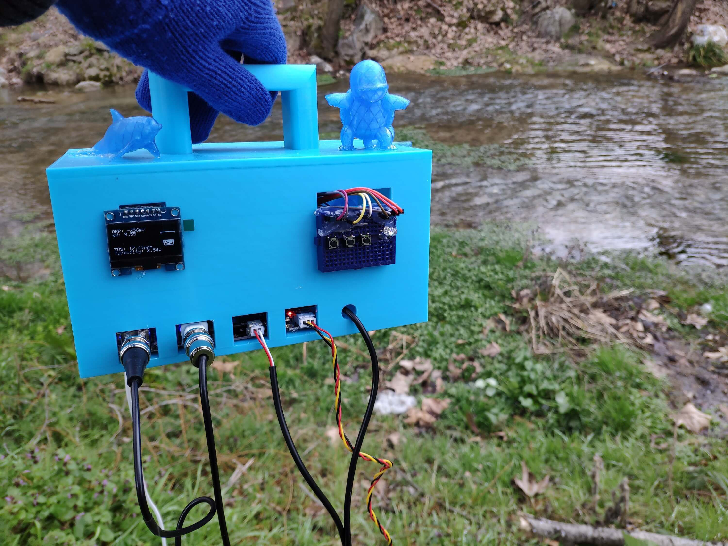
CanAirIO, a citizen science project that aims to gather air quality data from around the world by putting sensors into the hands of as many people as possible
Its team has developed two different sensor nodes for this purpose: an indoor one that can measure CO2, and a mobile one that can measure particulate matter (PM) levels. Both versions are powered by an ESP32 microcontroller that reads out the air quality sensors and connects to the Internet using Wi-Fi or Bluetooth. The data can then be shared online to create detailed maps showing local variations in air quality.
The design of the sensor nodes is fully open-source, allowing anyone with basic electronic skills to build them.
See Measuring Air Quality Using Mobile Sensors For The Masses
#technology #opensource #airpollution #citizenscience #CanAirIO

Poor air quality is a major problem for city dwellers the world over. Dust, smoke, particles and noxious gases from vehicles, industry and agriculture makes many megacities downright hazardous to l…
One person like that
One person like that
What's the difference traditional vaccine v gene therapy vaccine? This article uses easy to understand everyday language for non scientists to get a clear understanding of this subject. Make yourself a cup of #tea and have a read.
#education #nature #humanrights #marcusdebrun #ireland #science #ireland #citizenscience #genetherapy #vaccine #innoculation #knowledgeispower #knowledge
One person like that
Dashcam Detective Work Leads to Recovery of Space Rocks from Fireball over Slovenia
On 28 February 2020, at 10:30 CET, hundreds of people across Slovenia, Croatia, Italy, Austria and Hungary observed a bright ball of light hurtling across the morning sky. This delivery of rocks from a distant asteroid to the fields and villages of southern Slovenia was captured by cars’ dashcams, security cameras, and even a cyclist’s helmet. It is one of only around 40 fallen space rocks that has been recovered within weeks and for which the origins in the Solar System have been tracked.
7 Likes
1 Comments
1 Shares
One person like that
BMBF auf Twitter: "🐶 Gesucht: Hundehalterinnen & Hundehalter aus #SachsenAnhalt, #Berlin & #Sachsen. Ein Forschungsprojekt will die #Hunde in der Suche nach invasiven Arten 🌴trainieren. So werden die #Hunde 🐕 zur Spürnase für den #Artenschutz 🌿 👉 https://t.co/29vhFLSxKv #citizenscience https://t.co/cr7ZmPMNCv" / Twitter
https://twitter.com/BMBF_Bund/status/1408410933819494401
🐶 Gesucht: Hundehalterinnen & Hundehalter aus #SachsenAnhalt, #Berlin & #Sachsen. Ein Forschungsprojekt will die #Hunde in der Suche nach invasiven Arten 🌴trainieren. So werden die #Hunde 🐕 zur Spürnase für den #Artenschutz 🌿 👉 https://t.co/29vhFLSxKv #citizenscience pic.twitter.com/cr7ZmPMNCv
— BMBF (@BMBF_Bund) June 25, 2021
3 Likes
1 Shares