#maps

psychmesu@diaspora.glasswings.com

https://sciencemastodon.com/@oldmapgallery/113431242995831528 oldmapgallery@sciencemastodon.com - Can we do something lighter for today? The wonderful John Held Jr. and his map from c. 1930 of "A dog's idea of the ideal country estate" map.
John Held Jr was really an imaginative treasure of the time. Great illustrator and commentator on the culture of the time.

#maps #dog #map

psychmesu@diaspora.glasswings.com

https://hachyderm.io/@skinnylatte/113403489062225574 skinnylatte@hachyderm.io - a bunch of my coworkers are all going to singapore so i've been sharing my google maps of 113 places to eat in singapore

https://www.google.com/maps/@1.3506808,103.7668954,12z/data=!4m3!11m2!2snNbYpKuzTOqE2G50VXXf5A!3e3?entry=ttu&g_ep=EgoyMDI0MTAyOS4wIKXMDSoASAFQAw==

for people who like more context, the blog post accompanying it: https://popagandhi.com/food/my-singapore-list/

#Maps #Singapore #Food #TootSea #Travel #Blog

rhysy@diaspora.glasswings.com

The plaque from the 6th century BC shows a map of Mesopotamia – roughly where modern-day Iraq is – and what the Babylonians believed lay beyond the then-known world. The map shows Mesopotamia, which the ancient scribe called the “bitter river,” surrounded by a double ring. The river formed the border around the known Babylonian world. Within the bitter river, small circles and rectangles represent various Mesopotamian cities and tribes, including Babylon, while another rectangle represents the Euphrates River.

“When we operate beyond the known world into fantasy, this inscription becomes essential,” Finkel added. The Babylonian scribe mapped what he believed lay beyond his world. The map included mythical creatures and lands, and a familiar story from ancient history. This story is the Babylonian version of the biblical account of Noah’s Ark.

#History
#Archeology
#Maps

https://greekreporter.com/2024/09/13/babylonian-world-map-mesopotamia/

tina@diaspora.psyco.fr

Map Chart.

Si vous avez besoin de créer des cartes (créer une carte personnalisée pour un projet scolaire/universitaire, une présentation professionnelle, un prochain article de blog, etc).
L'utilisation est gratuite (mais on peut les soutenir), et Map Chart soumis à une licence internationale Creative Commons Attribution-ShareAlike 4.0 (CC BY-SA 4.0).

#cartes #maps #apps

kurt@pod.thing.org

Geile Scheiße

Post und DHL wechseln von Google Maps zu Openstreetmap

Die Deutsche #Post und auch #DHL nutzen #Google #Maps nicht mehr länger bei der #Paketverfolgung. Stattdessen setzen sie auf #Kartenmaterial von #Openstreetmap.

Natürlich nur wegen des Geldes und nicht weil die Post plötzlich Open Source für sich entdeckt hat. Bleibt zu hoffen daß sich das ändert und sie hilft, das Kartenmaterial zu verbessern.

https://www.golem.de/news/paketverfolgung-und-mehr-post-und-dhl-wechseln-von-google-maps-zu-openstreetmap-2404-184140.html

harryhaller@nerdpol.ch

avatar @Tina - original post

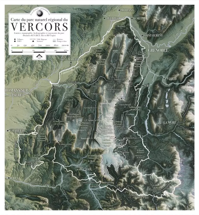
  1. Carte du parc naturel régional du Vercors. Limites, topographie, hydrographie, et toponymie du parc. Donénes IGN (RGE Alti et BD Topo).
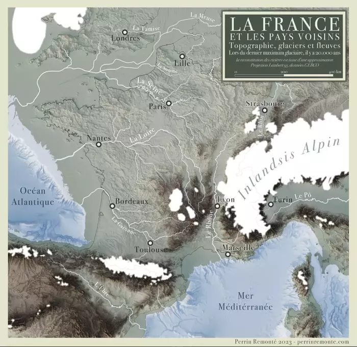
  2. Topographie, glaciers et fleuves lors du dernier maximum glaciaire, il y a 20 000 ans. La France et les pays voisins. La reconstitution des rivières est issue d'une approximation. Projection Lambert 93, données GEBCO.

Voir un peu plus des magnifiques cartes de Perrin Remonté ?... C'est ici.

(également auteur de magnifiques photos). (un blog à éplucher de fond en comble).

#Art #géographie #cartographie #photographie #cartes

#map #maps #nature #cartography #geography

utopiarte@tupambae.org

@permaCulture


Keith D Johnson - 2024-01-27 23:17:03 GMT

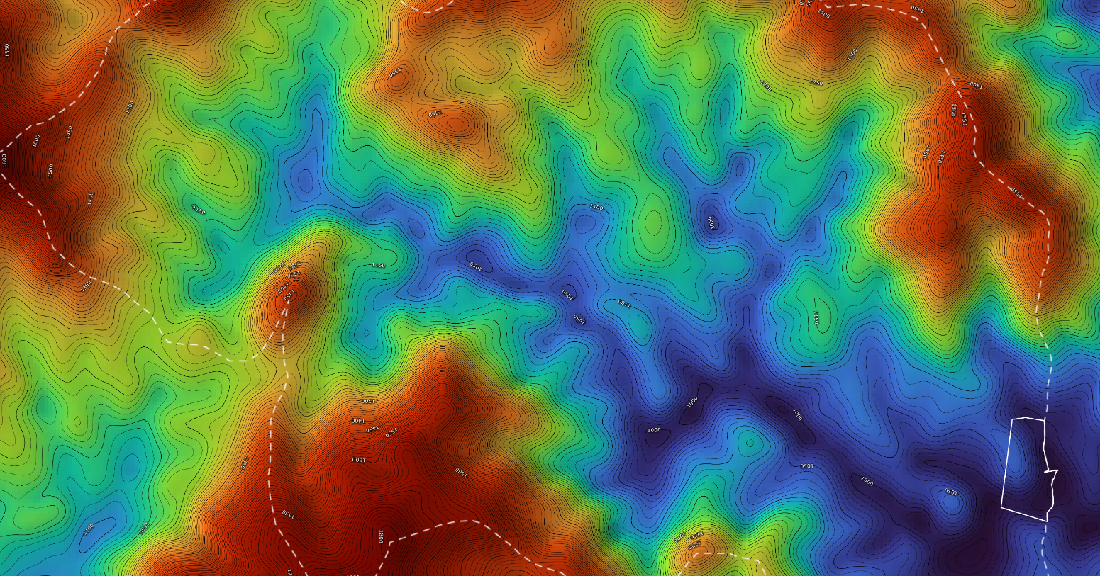
A friend of mine, Ben Missimer, makes #maps (& animated maps) to help others design their land for ecological resilience; basic contour maps, #hydrology, #forest cover, #wetlands, drainage, erosion, slope, #solar aspect, satellite images, & more (also all in large hi-rez, some suitable for framing & hanging on your walls).
He's okayed sharing these exemplary files. #permaculture #design https://www.dropbox.com/sh/qeb6nfvakmk81q1/AABw5yg-uSjwqHRWml8mOoG7a?dl=0If you need reasonably priced mapwork for your projects Ben's website is https://www.pearlriverecodesign.com/
Watershed elevation map rendered in a rainbow spectrum of colors from blue (lowland, wetland, drainage stream pattern; valleys) to red (upland, ridges watershed dividing lines, overlayed with lines on 1 ft contour intervals (yes, he also can do metric).