Your Clausian navigation challenges, explained.
https://generalaviationnews.com/2024/12/18/questions-from-the-cockpit-a-christmas-quandary/

2 Likes
Your Clausian navigation challenges, explained.
https://generalaviationnews.com/2024/12/18/questions-from-the-cockpit-a-christmas-quandary/
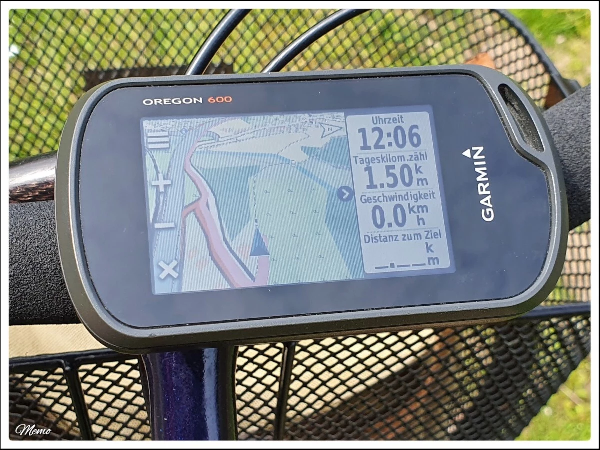
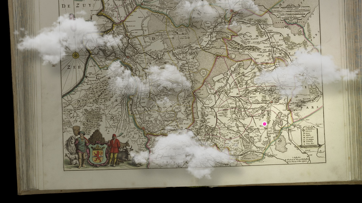
Ich habe soeben die aktuelle Version der #OFM ( #OpenFietsMap) vom 02. November, auf meinem #Garmin und in #BaseCamp installiert 🗺️ 🚲 😀
Nicht, dass ich die neueste Version unbedingt brauchen würde, aber wer weiß schon, wohin mich mein Fahrrad führt 😉
(Bildbeschreibung: Kartenansicht meines älteren Garmin Oregon 600, mittlerweile nutze ich fast ausschließlich den neuer Oregon 650, an einem Fahrradlenker.)
🔗 https://www.openfietsmap.nl/downloads/germany
#Rad #Fahrrad #Bike #Radtour #Navigation #Navi
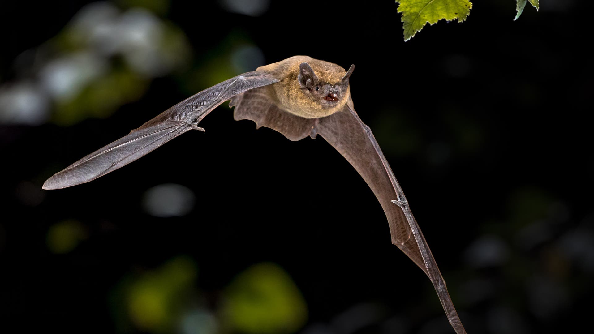
#Fledermäuse, die ihre Umwelt nur noch über #Echoortung wahrnehmen können, finden weiterhin ihren Weg zurück zu ihrer Kolonie. Das deutet darauf hin, dass das Gehirn der #Tiere dreidimensionale #Schallkarten ihrer Umgebung erstellt.
🔗 https://www.spektrum.de/news/navigation-auch-ganz-blind-finden-fledermaeuse-nach-hause/2240602
#Umwelt #Natur #Navigation
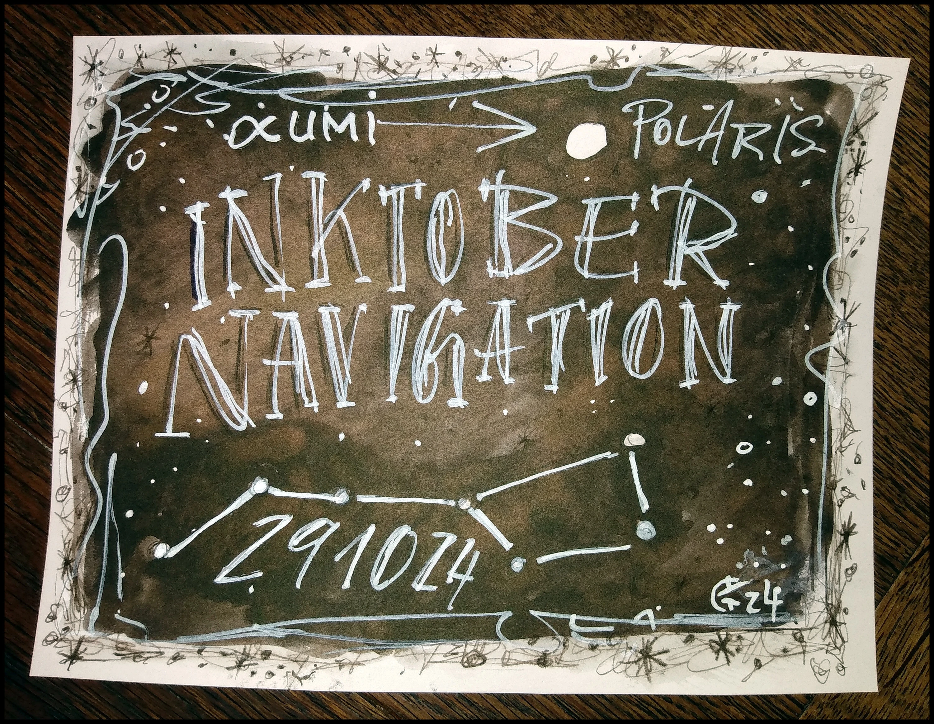
29 / Navigation
#AB, #no-29, #navigation, #AB-inktober, #ab-inktober-24, #inktober, #ink, #drawing, #Inktober24, #Inktober2024, #scribble, #doodle, #sketch, #challange, #improving, #art, #fun,
Un de plus, mais on ne le répètera jamais assez...
(et puis il y a toujours un soft ou un plugin qui va bien, qu'on ne connaissait pas).
#web #internet #numérique #vie-privée #protection #navigation
#science #history #navigation #3D
A great reconstitution!
https://piped.video/watch?v=3pYqXrFx6S8
https://www.youtube.com/watch?v=3pYqXrFx6S8

Ich habe soeben die aktuelle Version der #OFM ( #OpenFietsMap) vom 07. September, auf meinem #Garmin und in #BaseCamp installiert 🗺️ 🚲 😀
Nicht, dass ich die neueste Version unbedingt brauchen würde, aber wer weiß schon, wohin mich mein Fahrrad führt 😉
(Bildbeschreibung: Kartenansicht meines älteren Garmin Oregon 600, mittlerweile nutze ich fast ausschließlich den neuer Oregon 650, an einem Fahrradlenker.)
🔗 https://www.openfietsmap.nl/downloads/germany
#Rad #Fahrrad #Bike #Radtour #Navigation #Navi
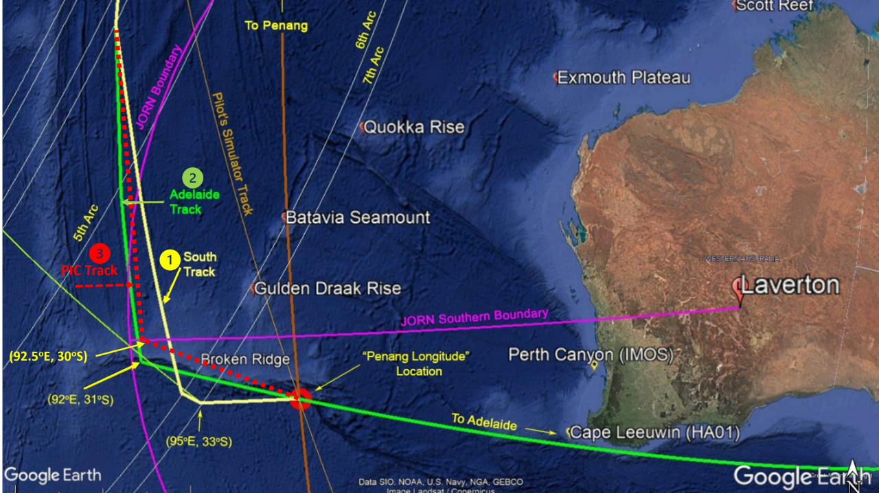
Source: https://www.linkedin.com/pulse/mystery-mh370-solved-science-vincent-lyne-46s3c/
This work changes the narrative of MH370’s -#disappearance from one of no-blame, fuel-starvation at the 7th arc, high-speed dive, to a #mastermind pilot almost executing an incredible perfect-disappearance in the Southern Indian #Ocean. In fact, it would have worked were it not for MH370 ploughing its right wing through a wave, and the discovery of the regular interrogation #satellite communications by Inmarsat—a brilliant discovery also announced in the Journal of #Navigation.
Eine neue Kamera ahmt winzige, unbewusste Augenbewegungen nach, so genannte Mikrosakkaden. So können Maschinen Objekte viel schneller erkennen und sich leichter zurechtfinden.#Kamera #Mikrosakkaden #Aufnahmetechnik #Detektor #Bionik #Augen #Ereigniskameras #Hochgeschwindigkeit #Robotik #Steuerung #Navigation #Selbstfahrend #ITTech
Ultraschnelle Kamera nach dem Prinzip des menschlichen Auges

Organic Maps is a free Android & iOS offline maps app for travellers, tourists, hikers, drivers, and cyclists based on OpenStreetMap data created by the community. It is a privacy-focused, open-source fork of Maps.me app (previously known as MapsWithMe), maintained by the same people who created MapsWithMe in 2011.
It is based on OpenStreetMaps, so I could see a little known trail in the middle of the Cederberg mountains in South Africa. The great thing though with OpenStreetMaps is, if something dos nor exist, you can just add it yourself.
It installs on iOS and Android phones (including from F-Droid and Obtanium), but I was also p[leased to see a Flatpak install for Linux desktops as well.
See organicmaps.app/
#Blog, #navigation, #opensource, #privacy, #technology, #trails

Ich habe soeben die aktuelle Version der #OFM ( #OpenFietsMap) vom 03. August, auf meinem #Garmin und in #BaseCamp installiert 🗺️ 🚲 😀
Nicht, dass ich die neueste Version unbedingt brauchen würde, aber wer weiß schon, wohin mich mein Fahrrad führt 😉
(Bildbeschreibung: Kartenansicht meines älteren Garmin Oregon 600, mittlerweile nutze ich fast ausschließlich den neuer Oregon 650, an einem Fahrradlenker.)
🔗 https://www.openfietsmap.nl/downloads/germany
#Rad #Fahrrad #Bike #Radtour #Navigation #Navi
Viele #Tiere finden sich mithilfe der #Sonne im Gelände zurecht. Das funktioniert sogar, wenn Wolken das Gestirn verdecken: Die Schwingungsrichtung der #Lichtwellen, #Polarisation genannt, verrät, woher das #Licht kommt. Auch wenn man die Quelle nicht direkt sehen kann, prägt sie dem diffusen #Umgebungslicht ihr Muster auf.
Diese Polarisation des #Sonnenlichts können zahlreiche #Tiere wahrnehmen und sich daran orientieren. #Bulldoggenameisen gelingt allerdings ein besonderes Kunststück: Sie nutzen die Polarisation des mehr als 50 000-fach schwächeren #Mondlichts.
🔗 https://www.spektrum.de/news/polarisation-des-mondlichts-fuehrt-ameisen-zurueck-zum-nest/2224723
#Umwelt #Natur #Navigation
"A short-haul aircraft in the United Kingdom recently became the first airborne platform to test delicate quantum technologies that could usher in a post-GPS world--in which satellite-based navigation (be it GPS, BeiDou, Galileo, or others) cedes its singular place as a trusted navigational tool."
"At the core of Infleqtion's technology is a state of matter called a Bose-Einstein condensate (BEC), which can be made to be extremely sensitive to acceleration."
That's... crazy.
"The best inertial systems in the world, based on ring laser gyroscopes, or fiber-optic gyroscopes, can...maintain a nautical mile of precision over about two weeks of mission."
"Max Perez, vice president for strategic initiatives at the Boulder, CO-based company Infleqtion, expects Infleqtion to be able to either maintain the same nautical-mile precision over a month or more mission time -- or, conversely, increase the sensitivity over a week's mission to something like one-tenth of a nautical mile."
That's nothing compared with GPS. And making Bose-Einstein condensate (BEC) is super hard. So, I think this is not the future. But it's an amazing idea. Maybe it can be used in the future for spacecraft? Anything traveling beyond Earth's orbit won't be able to use GPS anyway.
Quantum navigational tech takes flight in new trial
#solidstatelife #quantumphysics #boseeinsteincondensate #bec #navigation #accelerometer
Ich habe soeben die aktuelle Version der #OFM ( #OpenFietsMap) vom 06. Juli, auf meinem #Garmin und in #BaseCamp installiert 🗺️ 🚲 😀
Nicht, dass ich die neueste Version unbedingt brauchen würde, aber wer weiß schon, wohin mich mein Fahrrad führt 😉
(Bildbeschreibung: Kartenansicht meines älteren Garmin Oregon 600, mittlerweile nutze ich fast ausschließlich den neuer Oregon 650, an einem Fahrradlenker.)
🔗 https://www.openfietsmap.nl/downloads/germany
#Rad #Fahrrad #Bike #Radtour #Navigation #Navi
i am #crying
i am using #Osmand for #navigation. the #f-droid version. i was so lucky with it, a long while it ran great on my old #samsung #galaxy #s5 on #lineageOS but now the crashes are back and its unusable again which it was several (partly very long) periods in the past. i don't know what they are doing that its such a pain in the ass; maybe they have problems to do a good memory management. i am very sad, because i love that app and its plugins. it nearly is able to do everything you would like to do with such an app. when it runs. now i'll try it with #organicmaps. seems to be spartan but stable. and it has no trackers. if you have any further ideas, you are welcome.
Thomas Harriot hat als erster Mensch mit einem Teleskop astronomische Beobachtungen angstellt. Warum er trotzdem nicht so berühmt ist, wie er sein sollte, erfahrt ihr in der neuen Folge der Sternengeschichten. Wer den Podcast finanziell unterstützen möchte, kann das hier tun: Mit PayPal (paypal.me/florianfreistetter), Patreon (patreon.com/sternengeschichten) oder Steady (steadyhq.com/sternengeschichte…) 🎙️#Astronomie #Universum #Sternengeschichten #Astrodicticum #Sterne #ThomasHarriot #GalileoGalilei #1609 #HenryPercy #WalterRaleigh #NorthCarolina #Navigation #Algonkin #EarlofNorthumberland #GunpowderPlot #Mond #Mondkarte #HansLipperhey #55Cancrif #55Cancri #Dualsystem #Binärsystem #JohannFabricius #ChristophScheiner #AlbertGirard #ZachariasJanssen #Exoplanet #Sonnenflecken #Himmelsbeobachtung
Sternengeschichten Folge 595: Thomas Harriot, der erste moderne Astronom?