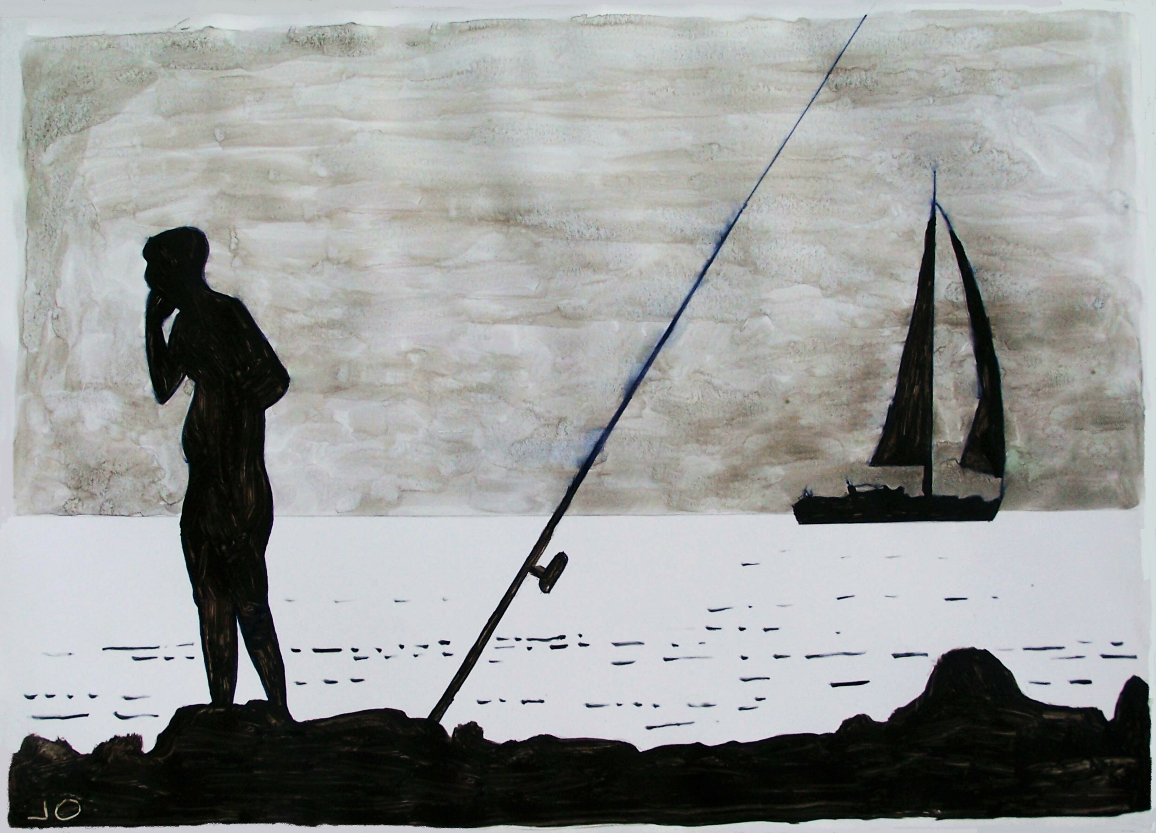
Boceto de hoy (n°4)
(33x24cm) "Pesca interrumpida".
#interrupted #fishing
#sketch #draft #sea #summer #navigation #sunset #backlighting #myart #mywork #JulioOjea #sailors #Tirreno
10 Likes
3 Comments
1 Shares
Boceto de hoy (n°4)
(33x24cm) "Pesca interrumpida".
#interrupted #fishing
#sketch #draft #sea #summer #navigation #sunset #backlighting #myart #mywork #JulioOjea #sailors #Tirreno
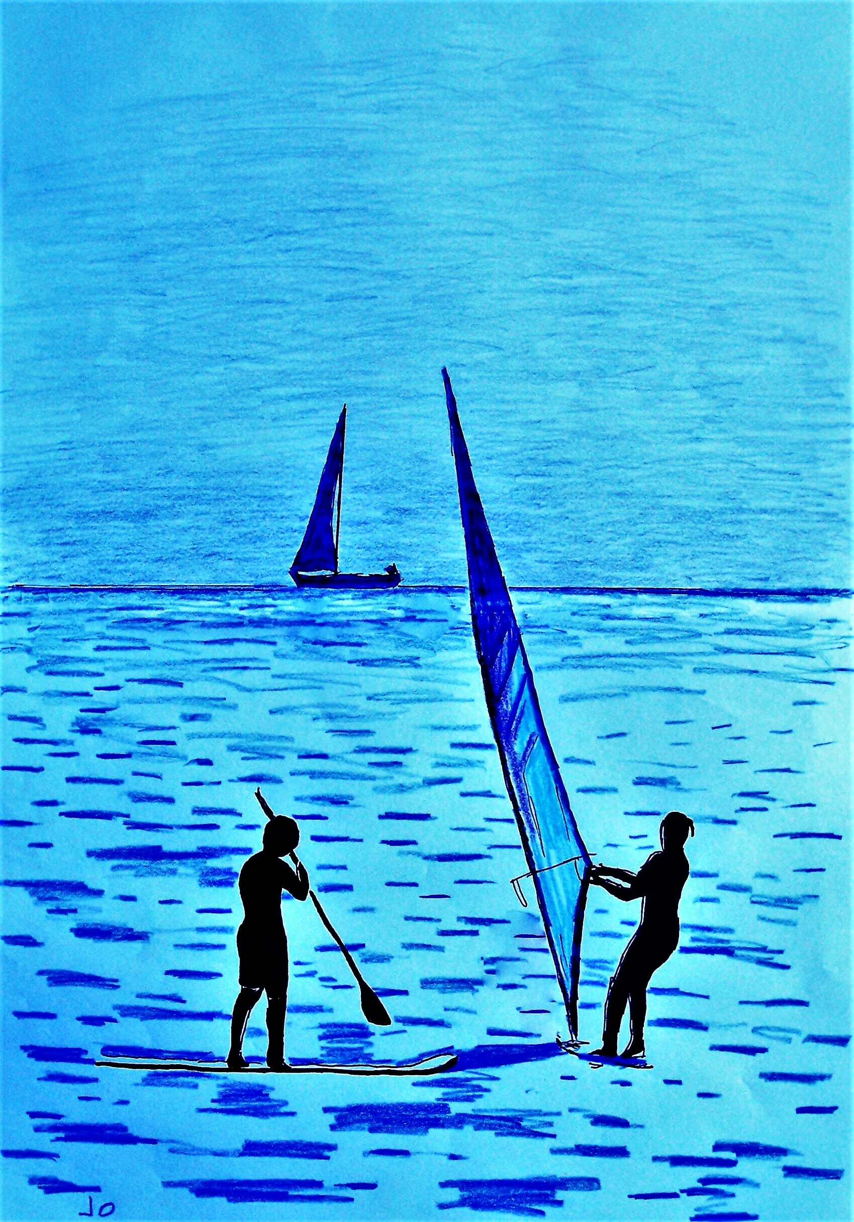
Boceto de hoy (n°3)
(30x42cm) para pròxima marina
con navegantes.
#sketch #draft #sea #summer #navigation #sunset #backlighting #myart #mywork #JulioOjea #sailors #Tirreno
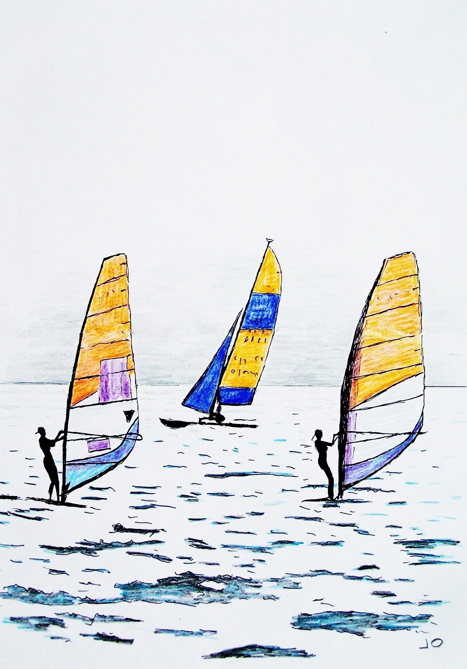
Boceto de hoy (n°2)
(30x42cm) para pròxima marina
con navegantes.
#sketch #draft #sea #summer #navigation #myart #mywork #JulioOjea #sailors #Tirreno
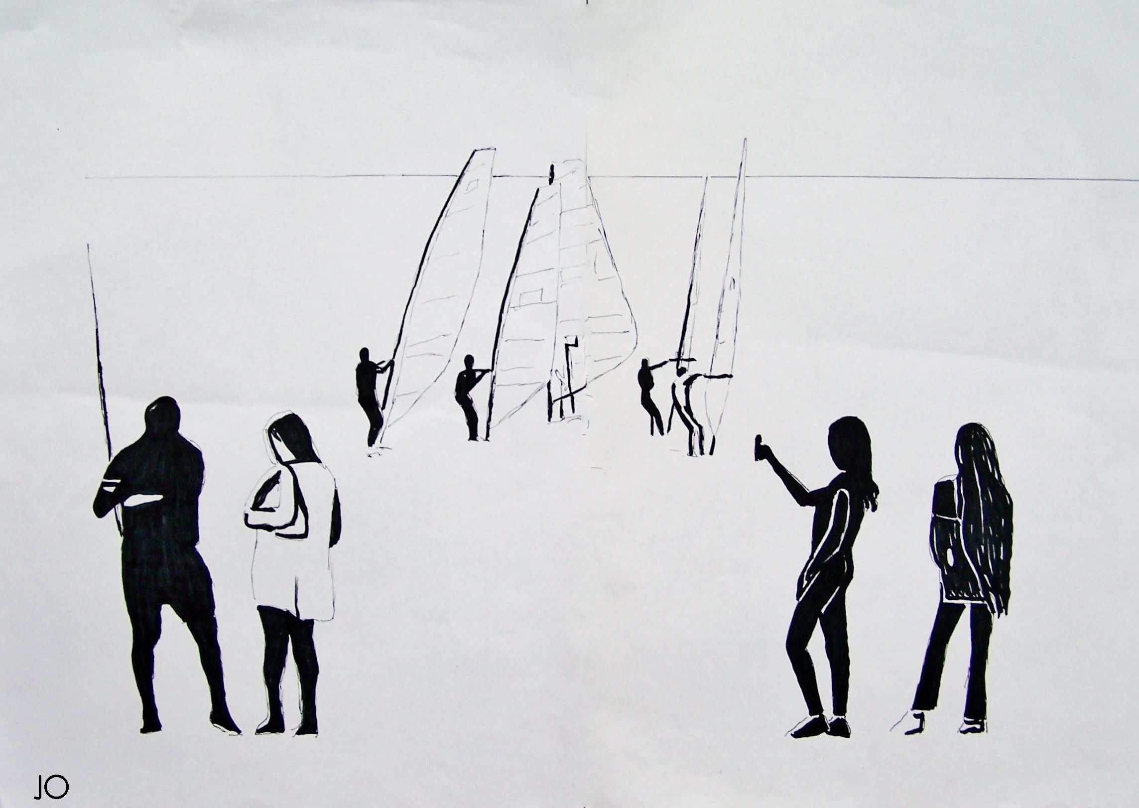
Boceto de hoy
(60x40cm) para pròxima marina
con pescadores, navegantes y jovencitas.
#sketch #draft #sea #summer #navigation #portrait #myart #mywork #JulioOjea #fishermen #sailors #youngGirls

Magic Earth now supports Advanced Driver Assistance System (ADAS) systems powered by the phone’s camera. The application can monitor the road ahead and provide functionality otherwise available in integrated ADAS technology fitted into the car. The application offers lane departure warnings, traffic sign recognition, and forward and pedestrian collision notifications.
The navigation application, which retains its focus on user privacy and offline route guidance, also brings most features to Android Auto. Magic Earth now supports truck navigation, letting users enter vehicle information. For example, the application can look for routes based on certain vehicle parameters, such as width, height, length, weight, and axle weight. Once all these details are provided, Magic Earth only configures appropriate routes, avoiding narrow roads, low bridges, and sharp curves.
I tested it out today, but in my case, the version I just downloaded did not yet recognise Android Auto. Just like OsmAnd it is based on OpenStreetMap. It has a much simpler, but I’d say better looking, interface than OsmAnd. Any new interface of course takes a bit of time to get used to. OsmAnd does also have all the truck navigation features previously mentioned, and it has a ton more settings and options (for example also speed bump and pedestrian crossing warnings), but many may find OsmAnd a bit more complex. If so, then Magic Earth may be well worth trying out.
Magic Earth says they are privacy first with no tracking, no profiling, don’t trade in our personal data, and don’t have our personal data.
It does have options for traffic and re-routing (and I’m not sure how the traffic data is working) but I suppose the proof of the pudding for many will be, how well does it route in real life. You can however also tweak these settings for cars, bicycles and walking (I imagine trucks is in the newer version I don’t seem to have yet).
See https://www.autoevolution.com/news/a-new-google-maps-alternative-launches-on-android-auto-with-massive-update-214097.html
#Blog, #MagicEarth, #navigation, #OpenStreetMap, #privacy, #technology

I was actually looking for a good navigator to import GPX tracks and Google Maps, Waze and similar do not do that. I remembered Waze was still looking to include speed bump warnings in future, and then I saw OsmAnd.
OsmAnd has dramatically improved over the last few years, and I immediately noticed (apart from the GPX track importing and offline navigation) that it now has voice alerts for speed bumps, pedestrian crossings, speed cameras, stop signs, and more. When I say more, that is an understatement, as it has a ton more stuff! It absolutely puts Google Maps and Waze to shame when it comes to the amazing details of customisation you can choose from, including also many different map sources and layers, and a lot of 3rd party plugins you can enable or disable too.
One 3rd party plugin for place reviews, called OpenPlaceReviews, looked very promising as a competitor to Google Reviews, but sadly it does not seem to have developed much. It also has integration with Wikipedia to find local places of interest.
But yes, the speed bumps and pedestrian crossings were all correct in my vicinity, and I see they come from OpenStreetMap data. If anything, there may be just too much packed in, so it is best not to try to activate everything.
It caters well too for hiking, cycling, walking, and other activities and when I looked up a very obscure hiking trail in the Cederberg Mountains, it appeared on the app. It also shows a lot of detail about trips and tracks with estimated times, elevations, and even factors in your vehicle’s details to track costs of journeys. You can record trips to play back the stats of each trip. The app is not just for driving on or off-road but is fully functional for hiking and other activities.
I just need to use it a bit more to try to gauge how good the routing really is. That said it can do routing also based on height, length, width, weight, etc restrictions of your vehicle (data permitting for your area). It also worked fine in my car with Android Auto.
There is also a route simulation mode that can help you test out how the app would work on a route you would like to use, for planning new routes, or for familiarising yourself with a route before you drive (or walk) it.
It is available for free for Android as well as iOS, including for Huawei, Amazon and F-Droid app stores. But it may take a bit of learning to really get the full benefits of this app.
See https://osmand.net/
#Blog, #navigation, #opensource, #OsmAnd, #technology
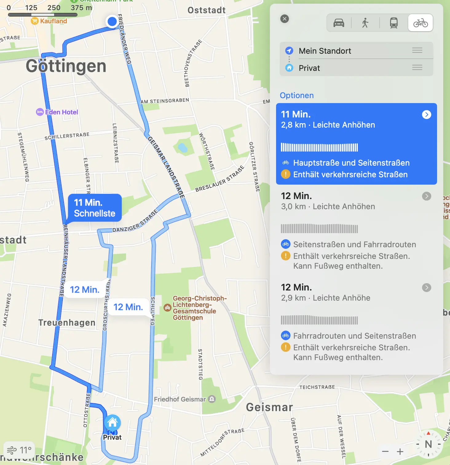
Apple hat jetzt eine Funktion zur Fahrradnavigation freigeschaltet. Sie haben sich damit viel Zeit gelassen, sodass ich dachte, das würde bestimmt ziemlich gut sein. Gerade habe ich den Test gemacht: Die Navigation ist jetzt nicht so schlecht, dass ich in einen Vulkan geleitet werde. Aber die App schlägt mir für den einfachen Nachhauseweg von der Arbeit drei Routen vor.
Die erste Route (angeblich die schnellste) würde ich so ganz sicher nicht fahren, weil ich die Straßenseite zweimal zu viel wechseln muss, sie vier Ampel hat, die extrem nervig sind, und diese Route führt an einer extrem befahrenen Autostraße entlang, wo die Laster und Busse mir mit 10 cm Abstand zum Lenker vorbei brausen. Man merkt schon: Vermutlich weiß Apple nichts von diesen Softskills. Aber zumindest das unnötige Wechseln der Straßenseite wurde bestimmt nicht einberechnet.
Die Routen 2 und 3 sind im Grunde okay, aber ich würde dennnoch keine von beiden so fahren. Beide enthalten zumindest eine merkbare Steigung, die ich mir auf einem anderen Wegabschnitt ohne Einbußen sparen kann. Das ist kein schlimmer Fehler, aber es wundert mich, dass Apple nicht mitbekommt, dass die eine Strecke bergauf führt und die andere bergab, aber beide gleich lang sind. Welche wird ein Radfahrer da schon wählen?
Ich habe die Radfahrnavigation noch mit einer auf OSM basierenden App, Guru Maps, ausprobiert. Und auch da wird mir eine subotimale Strecke vorgeschlagen, bei der ich viel zu viel unnötig bergauf fahren muss. Habt ihr gute Fahrradnavigationsapps im Einsatz?

Boceto para pròxima marina.
60x40 cm
disponibile prossimamente
#oilpainting and #sand on #canvas
#sketch #draft #sea #summer #navigation #portrait #myart #mywork #JulioOjea
#available very soon
source: https://www.theverge.com/2022/11/23/23474090/smartphone-next-big-thing-ar-vr-metaverse-alexa
Even the things that voice assistants and #AR glasses already do well, phones do better. #Voice dictation works impressively well on both #Android and #iOS, and #Google’s Live View in Maps is already a pretty good augmented-reality #navigation tool. You’ll get better and more fun #photos out of #Snapchat on your phone than you will with Spectacles. Most of the promise of the #metaverse is already taking place in #Fortnite and #Roblox.
Police have used “Fog Reveal” to search hundreds of billions of records from 250 million #mobile devices, and harnessed the data to create #location analyses known among law enforcement as “patterns of life,” according to thousands of pages of records about the #company.
#gps #spy #tracking #navigation #app #software #fail #problem #smartphone #news #economy
Le saviez-vous ?
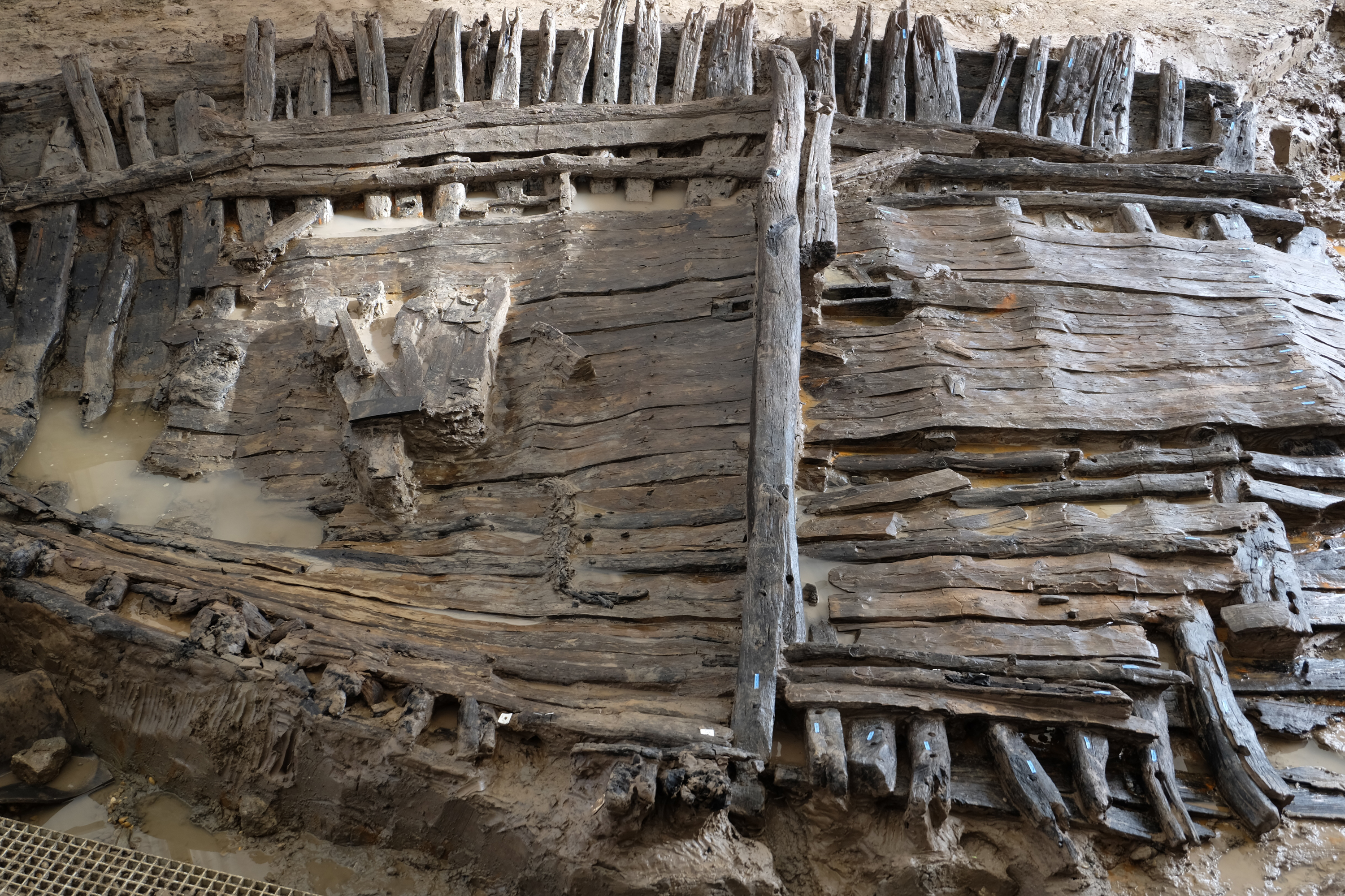
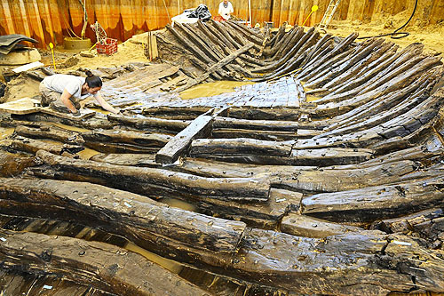
Les archéologues ont découvert une épave de bateau en bon état datant du VIIe ou VIIIe siècle de notre ère à Villenave d’Ornon près de Bordeaux.
https://www.inrap.fr/villenave-d-ornon-une-epave-de-bateau-du-haut-moyen-age-au-sud-de-bordeaux-16533#
#Histoire #Archéologie #HautMoyenâge #Navigation #Vestiges
US may disconnect Russia from GPS, space chief warns:
Russians shouldn’t be too nervous if this happens as they have their own GLONASS system, the head of Roscosmos has pointed out
#Shaban1443 #geospatial #gps #WorldWarZ #Ukraine #Russia #technology #navigation
Ukrainian soldiers were regrouped in a school, Among one a trooper posted this image on Social Media, Russians saw this post and the Same building was struck by a Russian Missile after 30 minutes. 14 Ukrainian soldiers were killed and many were wounded.
source: https://nitter.net/defensesentinel/status/1499161463352881153#m
How The #CIA Can Send A #Drone After Any #Mobile #Phone - https://www.fastcompany.com/3014675/how-the-cia-can-send-a-drone-after-any-mobile-phone
The Russians and all the other high-tech armies have the same technology! Turn your smartphone off to be sure.
If you really need it #online then preferably via #wifi or only briefly in places that are unimportant and far away from the actual shelter. For #offline #navigation use this app: https://f-droid.org/en/packages/net.osmand.plus/
#Danger #Warning #Security #Problem #Target #Military #Information #news #russia #ukraine #tracking
The information on Hiking Project is crowd-sourced, contributed by passionate users excited to share their knowledge of local trails with others. Anyone can share their experiences: add your favourite trails and photos, give ratings, post comments, improve existing content and spread the word about recommended routes. Your expertise brings an authentic voice to each trail and route.
So no features like overdue alerts to contacts or off-route alerting, but you can view your location on offline maps, record new trails, and share comments with others about conditions on a trail. A trail view shows the elevation overview, distance, hiker ratings scores, description with info, photos, driving directions to the start point, and recent feedback from other hikers on conditions.
I found a few trails in my neighbourhood (56 in South Africa), so your mileage will certainly vary by how active hikers in your area are who use the app. There is also a website for doing your planning, but you cannot manually create a map (you need to record it on the trail).
You can actually use the basics without even registering a profile at all (especially if you just want to navigate a trail). It may be worth also comparing what you get here with the free version of something like the AllTrails app, as that app has a ton more trails. Still, crowdsourcing new trails and giving feedback to others is a nice concept that Hiking Project has.
See Hiking Project | Hiking Trail Maps
#technology #navigation #hiking #trails #outdoors

/cdn.vox-cdn.com/uploads/chorus_asset/file/24020037/226270_iPHONE_14_PHO_akrales_0685.jpg)