#osmand

kurt@pod.thing.org

i am #crying

Osmand crashes again

i am using #Osmand for #navigation. the #f-droid version. i was so lucky with it, a long while it ran great on my old #samsung #galaxy #s5 on #lineageOS but now the crashes are back and its unusable again which it was several (partly very long) periods in the past. i don't know what they are doing that its such a pain in the ass; maybe they have problems to do a good memory management. i am very sad, because i love that app and its plugins. it nearly is able to do everything you would like to do with such an app. when it runs. now i'll try it with #organicmaps. seems to be spartan but stable. and it has no trackers. if you have any further ideas, you are welcome.

guillaumechocteau@diaspora-fr.org

Prenez un (excellent) smartphone Crosscall étanche et solide, en charge sur son support moto.
Suivez les indications d'un (excellent) GPS open source OsmAnd , respectueux et précis
Vous arrivez à bon port en Bretagne, même sous la tempête de samedi dernier !
Ajouté Coyote pour les dangers de toute sorte, la route est sûre !
Merci à eux pour la qualité de leurs productions

#crosscall #osmand #OpenStreetMap #coyote

caos@anonsys.net

🗺️ 📍 OpenStreetMap-Daten einfach bearbeiten mit Organic Maps und StreetComplete

Ich nutze ja schon länger #OrganicMaps und empfehle die App auch immer wieder als einfache Karten- und Navigations-App, die #OpenSource, auf #OSM -Basis ist und auch offline genutzt werden kann. Also eine schlankere Alternative zu #OSMand : https://gnulinux.ch/organic-maps

Erst heute habe ich aber per Zufall von @Tifi erfahren, dass mit Organic Maps auch sehr einfach OSM-Daten ergänzt und bearbeitet werden können :
Einfach draufdrücken, hochziehen & bearbeiten. Beim ersten Mal wird darauf hingewiesen, dass es einen OSM-Account braucht (inkl. Link zur Registrierung). Einmal eingeloggt, lassen sich Einträge super einfach bearbeiten.
"Einfach draufdrücken, hochziehen & bearbeiten. Beim ersten Mal wird darauf hingewiesen, dass es einen OSM-Account braucht (inkl. Link zur Registrierung). Einmal eingeloggt, lassen sich Einträge super einfach bearbeiten. (...) Neue Orte lassen sich ebenfalls durch langes drücken auf die gewünschte Stelle hinzufügen." Geht wirklich supereinfach!
@Organic Maps : Vielleicht habe ich was übersehen, aber auf Eurer Homepage könnte die Funktion auch zumindest erwähnt werden? https://organicmaps.app/de/ - ich finde es eine tolle Sache, auch wenn die meisten die Funktion nicht brauchen.

Eine weitere schöne Option, um zu OpenStreetMap beizutragen, ist #StreetComplete: Ein wirklich sehr einfacher und auch unterhaltsamer Weg, um sich am #OpenStreetMap -Projekt sinnvoll zu beteiligen.
"Diese App findet fehlende Kartendaten in deiner Nähe und zeigt diese als Aufgaben auf einer Karte an. Jede dieser Aufgaben kann vor Ort durch Beantwortung einer einfachen Frage gelöst werden." https://streetcomplete.app/
"Es gibt vielfältige Herausforderungen zu lösen. Tippt man dann auf das dementsprechende Pin, stellt die App dann eine Frage. Meist handelt es sich um Multiple-Choice-Fragen oder Eintippen von Ergänzungen. Die Fragen sind dabei grafisch ansprechend und mit Abbildungen versehen. (...) Ein Beispiel dazu: Ich tippe auf einen Pin mit einem Uhrensymbol. Mögliche Fragen sind dann die Öffnungszeiten eines Geschäftes, oder ob diese noch stimmen.
Es gibt Fragen zu Straßennamen, Hausnummern, Untergründen und Parkplätzen - um nur einige Beispiele zu nennen. Selbst Standorte von Mülleimern oder Pollern werden hinterfragt. Die Aufgaben sind so vielfältig" https://gnulinux.ch/streetcomplete
Auch diese App gibt es natürlich bei #FDroid: https://f-droid.org/packages/de.westnordost.streetcomplete/
@StreetComplete News & Support
Screenshots von Street-Complete: "Welche Hausnummer hat dieses Gebäude?" - "Was sind die Öffnungszeiten von Carls Weinbar?"

aktionfsa@diasp.eu

04.05.2023 Bei Topio wird einem geholfen

Ein privatsphäre-schützendes Handy ist möglich

... aber mühsam. Wir haben in einer zweiteiligen Sendung bei Alex TV, dem Offenen Kanal Berlin (OKB) bereits vor einigen Jahren über die Ein- und Zugriffe der datenhungrigen Unternehmen auf unsere Smartphones berichtet und vorgemacht, wie man auf einem Android Handy Google die Kontrolle entziehen kann. Dabei haben wir bemerkt, wie abhängig man dabei von der oft fehlenden Unterstützung für Gerätetreiber der Hersteller ist.

Nicht auf jedem Android Gerät funktioniert nach dem "rooten", der Befreiung des Geräts von Sperren auf den Adminzugriff, alles wie vorher. Deutschlandfunk Nova hat den Berliner Verein Topio in der alten Markthalle in Moabit besucht und sich die einzelnen Schritte und über auftretende Probleme berichten lassen.

Ein trackingsfreies Betriebssystem installieren

Anders als die vorinstallierten Betriebssysteme soll das Handy keine Infos an zum Beispiel Google senden. Dazu muss das Gerät zuerst einmal "geflasht" werden. Man entsperrt zuerst den sogenannten Bootloader und nimmt damit Google die Kontrolle über das Gerät. Bevor man sich daran wagt, solllte man schauen ob das für diesen Gerätetyp überhaupt erfolgreich funktionieren kann.

Danach installiert man z.B. als neues Betriebssystem "Lineage OS" und als App Store den freien F-Droid Store. Dort findet man offene Software für fast alle Anwendungen - aber sicher nicht Google Maps oder WhatsApp oder ... dafür aber sicher verschlüsselnde Messenger wie Briar, Wire, Sessions und die Karten von Open Street Map(OSM) und dazu das Navigationsprogramm OSMand, u.v.m.

Nach etwas Eingewöhnungszeit ist das Handy wieder vertraut. Höchstens auf Stauauskünfte in Echtzeit muss man auf einem trackingfreien Handy verzichten, denn sowas liefern die trackingfreien Apps nicht, denn sie verraten nicht wo ich mich gerade befinde. Spätestens mit der geringeren Anzahl von Spam-Nachrichten auf einem trackingfreien Handy und einem guten Gefühl wird man dann für den Aufwand belohnt.

Mehr dazu bei https://www.deutschlandfunknova.de/beitrag/daten-ein-verein-moechte-handys-von-tracking-befreien
Kategorie[21]: Unsere Themen in der Presse Short-Link dieser Seite: a-fsa.de/d/3tU
Link zu dieser Seite: https://www.aktion-freiheitstattangst.org/de/articles/8389-20230504-bei-topio-wird-einem-geholfen.htm
Link im Tor-Netzwerk: http://a6pdp5vmmw4zm5tifrc3qo2pyz7mvnk4zzimpesnckvzinubzmioddad.onion/de/articles/8389-20230504-bei-topio-wird-einem-geholfen.html
Tags: #Topio #Privatsphäre #Transparenz #Informationsfreiheit #Anonymisierung #Smartphone #Handy #Android #Befreiung #flashen #rooten #LineageOS #Briar #Wire #Sessions #F-Droid #OSMand #Verbraucherdatenschutz #Datenschutz #Datensicherheit

danie10@squeet.me

OsmAnd is an open source navigation app based on OpenStreetMaps with speed bump and pedestrian crossing notifications

Navgiation map view for driving show upcoming turns, stats for the route, etc
I was actually looking for a good navigator to import GPX tracks and Google Maps, Waze and similar do not do that. I remembered Waze was still looking to include speed bump warnings in future, and then I saw OsmAnd.

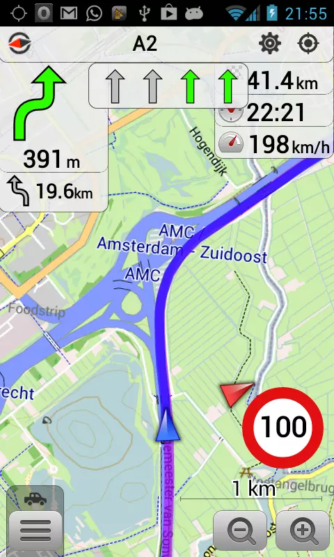
OsmAnd has dramatically improved over the last few years, and I immediately noticed (apart from the GPX track importing and offline navigation) that it now has voice alerts for speed bumps, pedestrian crossings, speed cameras, stop signs, and more. When I say more, that is an understatement, as it has a ton more stuff! It absolutely puts Google Maps and Waze to shame when it comes to the amazing details of customisation you can choose from, including also many different map sources and layers, and a lot of 3rd party plugins you can enable or disable too.

One 3rd party plugin for place reviews, called OpenPlaceReviews, looked very promising as a competitor to Google Reviews, but sadly it does not seem to have developed much. It also has integration with Wikipedia to find local places of interest.

But yes, the speed bumps and pedestrian crossings were all correct in my vicinity, and I see they come from OpenStreetMap data. If anything, there may be just too much packed in, so it is best not to try to activate everything.

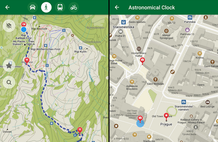
It caters well too for hiking, cycling, walking, and other activities and when I looked up a very obscure hiking trail in the Cederberg Mountains, it appeared on the app. It also shows a lot of detail about trips and tracks with estimated times, elevations, and even factors in your vehicle’s details to track costs of journeys. You can record trips to play back the stats of each trip. The app is not just for driving on or off-road but is fully functional for hiking and other activities.

I just need to use it a bit more to try to gauge how good the routing really is. That said it can do routing also based on height, length, width, weight, etc restrictions of your vehicle (data permitting for your area). It also worked fine in my car with Android Auto.

There is also a route simulation mode that can help you test out how the app would work on a route you would like to use, for planning new routes, or for familiarising yourself with a route before you drive (or walk) it.

It is available for free for Android as well as iOS, including for Huawei, Amazon and F-Droid app stores. But it may take a bit of learning to really get the full benefits of this app.

See https://osmand.net/
#Blog, #navigation, #opensource, #OsmAnd, #technology

amitabha@pod.orkz.net

GPS app alternatives

A while ago I announced to test other GPS apps to Waze and Google Maps, since I don't like Google products, I really don't like Google.
Previous Post

I mostly tested Here we Go, so here is the verdict:
- Live traffic works for highways and state roads.
- I was not sent into any weird streets, mud roads or small streets.
- Knows more than addresses, also knows shops and companies.
- Clear indication for highway exits.
- Some exits do not show all the cities shown on the exit sign.
- Sometimes not the most efficient way.
- A bit of an awkward robotic voice for guidance.

So basically it does the trick, with some small negative point, but I will keep using it.

I didn't really got to testing OSMAnd, first interactions were a bit clumsy, but I want to test it through.

On the other hand I tested Organic Maps and this is the ideal walking app.
- It works in the city and in nature.
- All small walking routes are indicated.
- You can plan a walking trip with different points.
- Clean useful interface and a direction indicator that works.
- Based on Openstreetmaps
- It's FLOSS.
- Can't say I found negative points.

Please comment with any other tips or additions.

#gps #waze #googlemaps #herewego #osmand #organicmaps #smartphone #opensource #floss

oliver@societas.online

Ich hätte mir vor dem Urlaub mehr Gedanken über eine gute App zu #Outdoor #Trekking #Wandern #Hiking machen sollen. Die bekanntesten sind wohl #outdooractive und #komoot, ich habe es mit #Osmand versucht. Nun bin ich bei #LocusMap4, die schon einen sehr guten Eindruck macht. Es gibt auch noch #LocusMap3, früher #LocusMap-Pro. Das Problem ist: Oft ist die App oder Karten und andere Funktionen kostenpflichtig. Wenn man nur ausprobieren will, dann versenkt man das Geld, wenn man sich am Ende doch für eine andere App entscheidet. Immerhin: LocusMap (alle Versionen) bieten einen erheblichen Funktionsumfang. Da werde ich mich noch eingehend mit auseinandersetzen. Bislang hat es im Urlaub auch so gut geklappt und wir haben tolle Wanderrouten gefunden, teils über Webseiten, teils über Komoot (Freundin). Wir hatten schon wirklich tolle Aufstiege, Aussichten und Wanderungen durch Schluchten, wobei wir am liebsten abseits der offiziellen Wanderwege unterwegs sind. Also eher da, wo auch die Kletterer unterwegs sind und der Durchschnittswanderer nicht läuft.

toaskoas@pod.geraspora.de

Ich mache mit #OsmAnd Foto-Notizen. Diese möchte ich gerne automatisch auf meinen Laptop synchronisieren. Jetzt dachte ich mir ich mache das mit Syncthing. Aber in den Ordner komme ich gar nicht rein von #Syncthing aus. Android/Data wird mir nicht angezeigt. Wie löst ihr das?

ictus@diasp.org

Android Apps

I don't like Android and using Google Android is simply dumb. It just makes no sense to present one's data on a silver tablet to Google. Ungoogled Android has a big advantage though: It has many apps. Here are some of them, which were mentioned in a video by mobilsicher (if I remember correctly). These are from f-droid.

  • VLC
  • Antennapad
  • RadioDroid
  • Soundrecorder
  • ScreenCam # #
  • Fennic
  • Tor Browser
  • Orbot
  • Blokada
  • NetGuard
  • SimpleSearch # #
  • K-9
  • FairEmail
  • DeltaChat

- JitsiMeet

  • FaceSlim
  • SlimSocial
  • NewPipe
  • Tusky #
  • FitoTrack
  • OpenFoodFacts
  • Meine Ausgaben #
  • Öffi
  • OsmAnd #
  • AnySoftKeyboard
  • Simple Mobile Tools #
  • OpenSudoku
  • Wikipedia # # SOME MORE: #
  • Aurora Droid (f-droid alternative)
  • PilferShush Jammer (blocks the microphone)
  • Net Monitor (SECUSO) (checking connections)
  • ClassyShark (checking apps for trackers) #
  • Exodus Privacy (checking the system for trackers)
  • Afwall+ (firewall)
  • Checkey (checking apps for authenticity)
  • WebApps (websites as webapps) #
  • Signal (messenger)
  • Briar (messenger)
  • Conversations (xmpp messenger)
  • SkyTube (youtube)
  • quickdic (offline word translator) #
  • Privacy Browser
  • Mac Address Ghost (changing mac)
  • OpenContacts (protect contacts in a separate app)
  • Shelter (container)
  • Port Authority (port scans) #
  • Aegis (2FA)
  • Tower Jumper (game)
  • Pixel Wheels (game)
  • Apple Flinger (game) #

These are useful apps. E.g. for checking system connections Net Monitor (from SECUSO) is helpful. Or for just for a simple test, for example: In "Settings/Apps/Signal/Data Usage" activate the last three options (blocking mobile, wifi and vpn connections at the same time).
Check via Net Monitor, if the app's connections are indeed blocked (not showing via Net Monitor, swipe down to refresh).

#android #apps #androidapps #gnu #linux #gnulinux #vlc #security #blokada #privacy #netmonitor #afwall #checkey #hackernews #signal #briar #xmpp #conversations #pixelwheels #towerjumper #classyshark #exodusprivacy #skytube #newpipe #radiodroid #aegis #osmand