#cartography


GIS software company ESRI is shutting down internal conversations about whether or not their products are being used by the Israel Defense Forces - from an employee
EDITORIAL NOTE: Further reason to use FOSS4G? This report is uncorroborated, but seems to square with Environmental Systems Research Institute Inc's policies.
Throwaway account--trying to post in a few subs because I think this is important.
For those who don't know, ESRI creates Geographic Information Systems software. This software is used for making maps and spatial analysis, among other things. If you work in GIS, or use maps, you've probably used this software. Now for the important part.
On Monday, December 11, 2023, an employee posted in the HR Teams channel to ask the question: "Is the Israeli Defense Force (IDF) using ArcGIS to help with the current bombings in Gaza?" The employee went on to explain that they had reached out to HR with this question and was told that "the specific information you are requesting is not going to be supplied to you. We would need permission from a distributor or customer to provide specific information about products sold or used and we don't have said permission."
The employee went on to explain that they thought it was important for ESRI employees to know this information. The employee also inquired if others were concerned and wanted answers. The employee also pointed out that ESRI had taken a political stand previously with regard to Ukraine and Russia and provided a screenshot of an official ESRI statement that said: "Esri stands in solidarity with Ukraine and the Ukrainian people. Our software is not and will not be deployed in any military or intel organization in Russia. Esri distributor CIS is curtailing sales in Russia. We are actively supporting the humanitarian efforts in Ukraine, and we continue to work with many European countries, as well as NATO, the United Nations, and the US State Department. Esri will do everything we can to help Ukraine and its people."
The post garnered a lot of attention and support from other employees. Several responded that they were concerned that ESRI is providing software for a genocide. The specific word "genocide" was used a few times. There was one dissenting comment.
On Wednesday, December 20, 2023, another employee commented on the thread to say that the original poster had resigned on Friday, December 15, 2023, due to "lack of answers from the administration."
Later that day, an email was sent out about a new policy with regard to the digital environment and appropriate business conduct.
Today, December 21, 2023, the entire thread and all of the responses were deleted, presumably by HR, since they manage the channel. An HR team member replied and said that "there were many posts involving sensitive topics and comments that were not appropriate for a business setting. I have received numerous inquiries and employees stating that they feel uncomfortable with the messaging and tone in these posts." Meanwhile, a separate post in the same channel, made on October 15, 2023, titled "Condemning the terrorist attacks in Israel" stayed up. It would seem that ESRI is not concerned with the discomfort of their Palestinian employees.
I am an ESRI employee and I am furious. ESRI talks about their commitment to making the world a better place while shutting down conversations by their employees about genocide. I don't think it's a secret that ESRI operates this way, but I wanted to share what's happening on the inside. Many of us are angry and we won't be silenced.
#Shaban1445 #GIS #Israel #ArcGIS #war #antiwar #technology #Gaza #Palestine #warcrimes #genocide #Esri #BDS #OSM #FOSS4G #openstreetmap #opensource #ethics #corporateethics #politics #ukraine #russia #rothschildistan #map #mapping #countermapping #cartography #geospatial #geography
#military #militarytechnology #QGIS #GRASSGIS #IDF #IOF
@Tina - original post

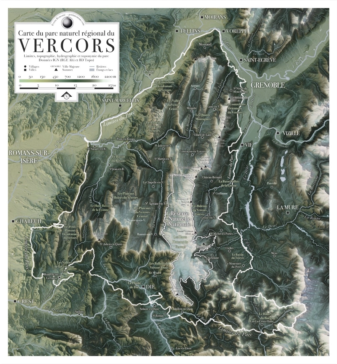
- Carte du parc naturel régional du Vercors. Limites, topographie, hydrographie, et toponymie du parc. Donénes IGN (RGE Alti et BD Topo).
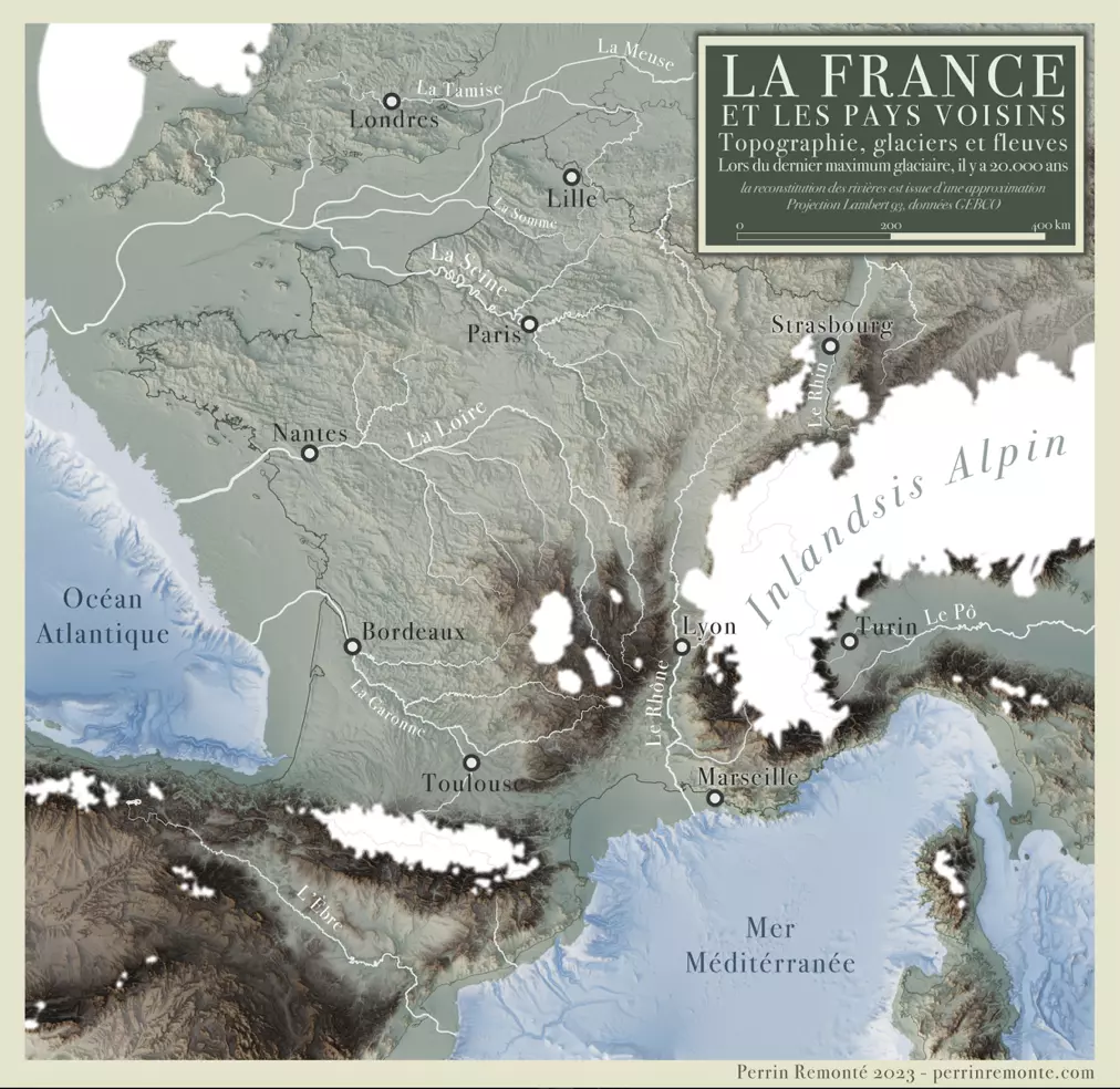
- Topographie, glaciers et fleuves lors du dernier maximum glaciaire, il y a 20 000 ans. La France et les pays voisins. La reconstitution des rivières est issue d'une approximation. Projection Lambert 93, données GEBCO.
Voir un peu plus des magnifiques cartes de Perrin Remonté ?... C'est ici.
(également auteur de magnifiques photos). (un blog à éplucher de fond en comble).
Carte
« Une carte n’est pas le territoire », a dit Alfred Korzybski
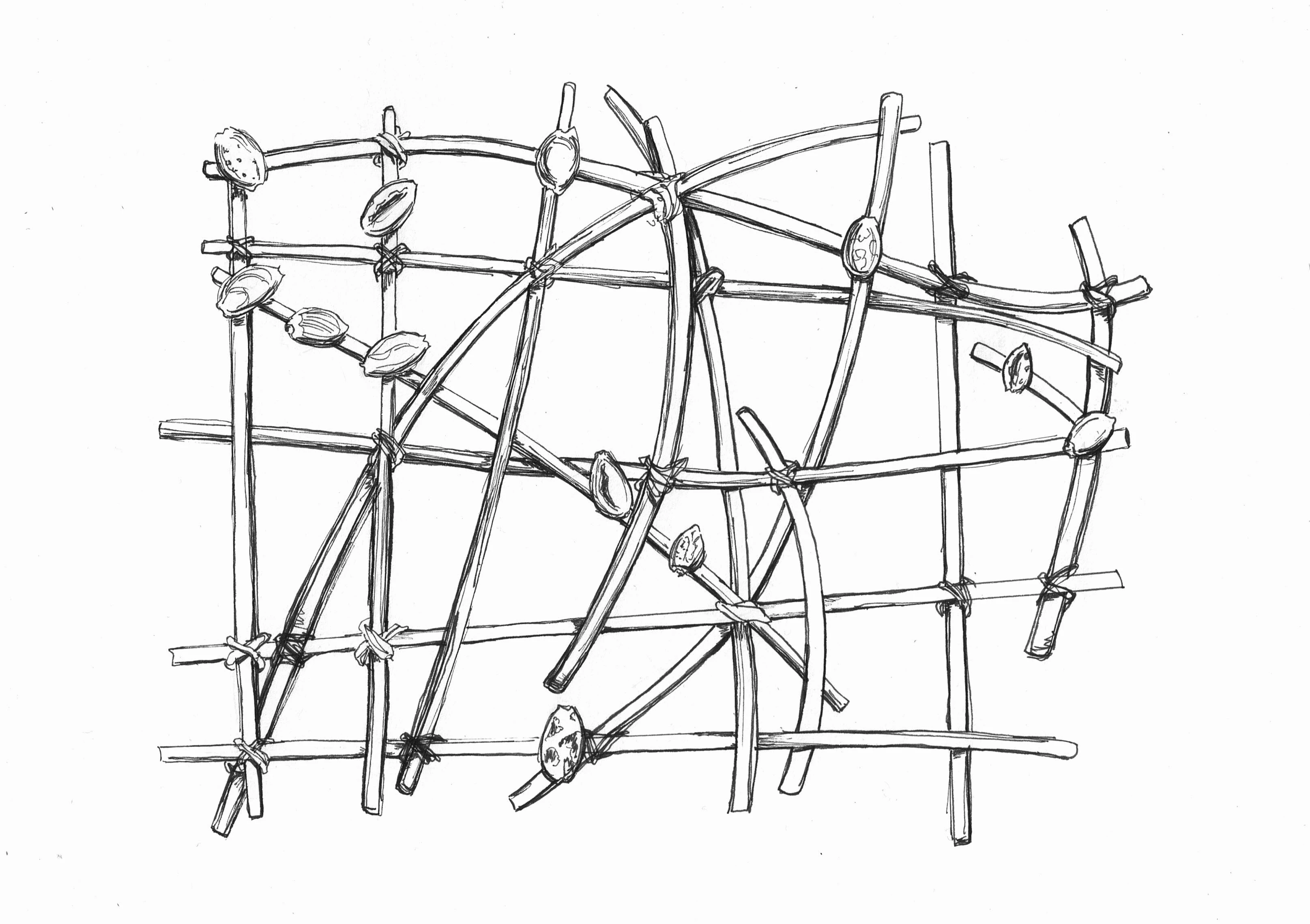
Les civilisations inventent leur propre représentation du Monde. Support d’apprentissage de la navigation, les cartes à bâtonnets polynésiennes permettaient aux piroguiers de mémoriser les courants marins et les îles (représentées par les coquillages). Celle que j’ai dessiné s’en inspire, même si elle est totalement fantaisiste. Une navigateur océanien la trouverait probablement absurde, si tant est qu’il y ait encore de nos jours des gens qui sachent lire ce type de carte.
Et pourtant, en la dessinant, j’eus l’impression un moment de me perdre doucement dans le clapotement paisible des vagues, le chant envoûtant des piroguiers…
« Ho-e a-na… Ho-e a-na... »
#carte #carteàbâtonnets #map #stickmap #stickchart #polynésie #polynesia #Oceania #Pacific #géographie #geography #cartographie #cartography #geografia #cartographia #géo #carto #inktober #inktober2023 #dessin #drawing #gribouillage #art #amateur #mywork #d3 #enjomineur
Mapping the fires and their consequences.
https://www.cbc.ca/news/canada/alberta-wildfires-map-1.6838361
#Alberta #wildfires #ClimateDerangement #mapmaking #cartography #smoke #ecologicaleffects #Canada #NorthAmerica

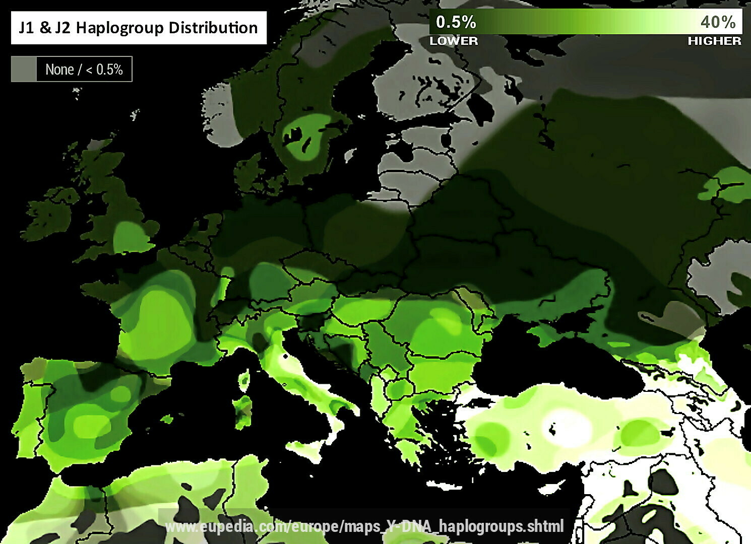
Composite map of J1 & J2 Y-Haplogroup distribution in Europe, parts of North Africa & parts of the near-East. Interesting to see the clustering spikes in Italy, France, Southern UK, Southern Sweden, Turkey, Russia, Albania, Moldova & Corsica. Why cluster here?
#haplogroups #haplogroupclustering #ethnography #j1 #j2 #ethnicity #eu #ethnolinguistics #genetics #jews #jewish #afroasiatic #migration #usa #diaspora #jewishdiaspora #europe #uk #africa #neareast #italy #france #sweden #russia #albania #moldova #corsica #immigration #infiltration #elevation #nepotism #usurpation #corruption #destruction #semitism #abrahamism #ideologicalhegemony #abrahamicideologicalcolonialism #judeoangloamericanempire #usa #map #cartography #elites #elitism #globalism #globalists #control
Map of airports. There are a lot more airports around me than I realized. You might find there are a lot more around you, too. The map can show heliports as well. And seaplane bases as well, though there aren't any of those around me (I'm in Colorado). You can also have it show military bases.
For regular airports, you can filter by whether the airport is public or private. There are a lot of private airports.
The map layers FAA visual flight rules (VFR) sectional charts onto the map as well.
The site is called "Pirep", though I don't know where the name "Pirep" comes from. It's basically an open-source database of airports that any pilot can contribute to.
"Pirep is my love letter to our aviation infrastructure. When I first started flying I had no idea about where to find transient parking, pilot lounges, or fuel pumps, if an airport had crew cars/bikes, or really any of the unpublished, local knowledge that only came from walking around an airport."
"As I slowly expanded my personal knowledge base of information I realized how valuable it could be to others and how valuable their knowledge bases would be to me. I created Pirep for pilots to contribute to a shared source of the unpublished information about airports and to hopefully discover new destinations & adventures."
OpenStreetMap 2012 vs 2022. Side-by-side comparison centered around New York. Much more detail in the 2022 version.
Pangaea with modern international borders

#maps #cartography #geography #palaeontology #Pangaea #countries #geology

Travel Distances in Days from London,
only a 100 years ago :-)
#travel #speed #time #history #world #map #cartography
(OP made by @Hacker News)
